
Faire un don
Équipez-vous pour votre prochaine aventure :
En tant que Partenaire Amazon, ce site perçoit une commission sur les achats éligibles sans surcoût pour vous.
Carte topographique Schuylkill Haven
Cliquez sur la carte pour afficher l’altitude.
Faire un don
Équipez-vous pour votre prochaine aventure :
En tant que Partenaire Amazon, ce site perçoit une commission sur les achats éligibles sans surcoût pour vous.
Schuylkill Haven
Schuylkill Haven was developed around the Schuylkill River, which flows through the town entering northwest of Island Park near Fritz Reed Avenue, and exits at the southeastern border. The river's elevation in the borough is approximately 490 feet (150 m) above sea level. Farther from the river, the borough extends up numerous hills, reaching its highest elevation at approximately 700 feet (210 m) above sea level near the top of Avenue C.
Faire un don
Équipez-vous pour votre prochaine aventure :
En tant que Partenaire Amazon, ce site perçoit une commission sur les achats éligibles sans surcoût pour vous.
À propos de cette carte
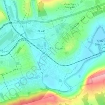
Nom : Carte topographique Schuylkill Haven, altitude, relief.
Altitude moyenne : 184 m
Altitude minimum : 147 m
Altitude maximum : 287 m
Faire un don
Équipez-vous pour votre prochaine aventure :
En tant que Partenaire Amazon, ce site perçoit une commission sur les achats éligibles sans surcoût pour vous.