
Carte topographique Hagerstown
Carte interactive
Cliquez sur la carte pour afficher l’altitude.
À propos de cette carte
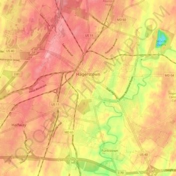
Nom : Carte topographique Hagerstown, altitude, relief.
Lieu : Hagerstown, Washington County, Maryland, United States (39.60003 -77.77309 39.67373 -77.67228)
Altitude moyenne : 170 m
Altitude minimum : 102 m
Altitude maximum : 204 m
Hagerstown has a distinct topography, formed by stone ridges running from northeast to southwest through the center of town. Geography accordingly bounds its neighborhoods. These ridges consist of upper Stonehenge limestone. Many of the older buildings were built from this stone, which is easily quarried and dressed onsite. It whitens in weathering and the edgewise conglomerate and wavy laminae become distinctly visible, giving a handsome and uniquely "Cumberland Valley" appearance. Several of Hagerstown's churches are constructed of Stonehenge limestone. Its value and beauty as building rock may be seen particularly in St. John's Episcopal Church on West Antietam Street and the Presbyterian Church at the corner of Washington and Prospect Streets. Brick and concrete eventually displaced this native stone in the construction process.[6]
Autres cartes topographiques
Cliquez sur une carte pour visualiser sa topographie, son altitude et son relief.
Weverton
United States > Maryland > Washington County
Weverton, Washington County, Maryland, 21758, United States
Altitude moyenne : 153 m
Hancock
United States > Maryland > Washington County
Hancock, Washington County, Maryland, United States
Altitude moyenne : 167 m
Hancock
United States > Maryland > Washington County > Hancock > Hancock
Hancock, Washington County, Maryland, 21750, United States
Altitude moyenne : 166 m
Keedysville
United States > Maryland > Washington County > Keedysville
Keedysville, Washington County, Maryland, United States
Altitude moyenne : 129 m
Sharpsburg
United States > Maryland > Washington County
Sharpsburg, Washington County, Maryland, United States
Altitude moyenne : 138 m