
Carte topographique Heist
Carte interactive
Cliquez sur la carte pour afficher l’altitude.
À propos de cette carte
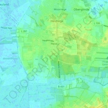
Nom : Carte topographique Heist, altitude, relief.
Altitude moyenne : 6 m
Altitude minimum : -2 m
Altitude maximum : 17 m
Autres cartes topographiques
Cliquez sur une carte pour visualiser sa topographie, son altitude et son relief.
Tangstedt
Duitsland > Sleeswijk-Holstein > Kreis Pinneberg
Tangstedt, Pinnau, Kreis Pinneberg, Sleeswijk-Holstein, 25499, Duitsland
Altitude moyenne : 11 m