
Faire un don
Équipez-vous pour votre prochaine aventure :
En tant que Partenaire Amazon, ce site perçoit une commission sur les achats éligibles sans surcoût pour vous.
Carte topographique Kiawah Island
Cliquez sur la carte pour afficher l’altitude.
Faire un don
Équipez-vous pour votre prochaine aventure :
En tant que Partenaire Amazon, ce site perçoit une commission sur les achats éligibles sans surcoût pour vous.
Kiawah Island
Kiawah Island features a low-lying, sandy topography typical of barrier islands along the southeastern coast of the United States. The island's average elevation is about 10 feet above sea level, with some areas reaching slightly higher. Its terrain is characterized by broad, flat beaches that gently slope into the Atlantic Ocean, interspersed with lush maritime forests and salt marshes. These ecosystems create a rich biodiversity, supporting a variety of wildlife. The landscape includes both freshwater lagoons and saltwater estuaries, contributing to its unique ecological environment. Overall, Kiawah Island's topography offers a serene natural setting that enhances its appeal as a vacation destination.
Faire un don
Équipez-vous pour votre prochaine aventure :
En tant que Partenaire Amazon, ce site perçoit une commission sur les achats éligibles sans surcoût pour vous.
À propos de cette carte
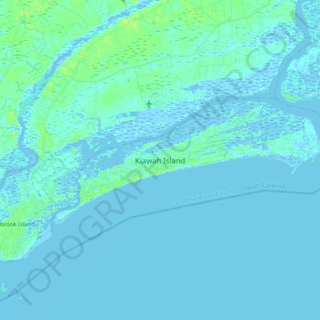
Nom : Carte topographique Kiawah Island, altitude, relief.
Altitude moyenne : 2 m
Altitude minimum : -3 m
Altitude maximum : 13 m
Faire un don
Équipez-vous pour votre prochaine aventure :
En tant que Partenaire Amazon, ce site perçoit une commission sur les achats éligibles sans surcoût pour vous.
Autres cartes topographiques
Cliquez sur une carte pour visualiser sa topographie, son altitude et son relief.
Hobcaw Point
United States > South Carolina > Charleston County > Mount Pleasant
Altitude moyenne : 4 m
Faire un don
Équipez-vous pour votre prochaine aventure :
En tant que Partenaire Amazon, ce site perçoit une commission sur les achats éligibles sans surcoût pour vous.
Saint Andrews Heights
United States > South Carolina > Charleston County > Charleston
Altitude moyenne : 5 m
Pinewood Vista
United States > South Carolina > Charleston County > North Charleston
Altitude moyenne : 9 m
Palmetto Fort
United States > South Carolina > Charleston County > Mount Pleasant
Altitude moyenne : 4 m
Faire un don
Équipez-vous pour votre prochaine aventure :
En tant que Partenaire Amazon, ce site perçoit une commission sur les achats éligibles sans surcoût pour vous.
Jamestown Estates
United States > South Carolina > Charleston County > James Island
Altitude moyenne : 4 m
Brook Green Meadow
United States > South Carolina > Charleston County > Mount Pleasant
Altitude moyenne : 4 m
Faire un don
Équipez-vous pour votre prochaine aventure :
En tant que Partenaire Amazon, ce site perçoit une commission sur les achats éligibles sans surcoût pour vous.
Faire un don
Équipez-vous pour votre prochaine aventure :
En tant que Partenaire Amazon, ce site perçoit une commission sur les achats éligibles sans surcoût pour vous.
Faire un don
Équipez-vous pour votre prochaine aventure :
En tant que Partenaire Amazon, ce site perçoit une commission sur les achats éligibles sans surcoût pour vous.
Camp Saint Christopher
United States > South Carolina > Charleston County > Seabrook Island
Altitude moyenne : 2 m
Remleys Point
United States > South Carolina > Charleston County > Mount Pleasant
Altitude moyenne : 4 m
Faire un don
Équipez-vous pour votre prochaine aventure :
En tant que Partenaire Amazon, ce site perçoit une commission sur les achats éligibles sans surcoût pour vous.
North Charleston Wannamaker County Park
United States > South Carolina > Charleston County > North Charleston
Altitude moyenne : 8 m
Faire un don
Équipez-vous pour votre prochaine aventure :
En tant que Partenaire Amazon, ce site perçoit une commission sur les achats éligibles sans surcoût pour vous.
Forest Park
United States > South Carolina > Charleston County > Charleston > Maryville
Altitude moyenne : 5 m
Wando Estates
United States > South Carolina > Charleston County > Mount Pleasant
Altitude moyenne : 5 m
Faire un don
Équipez-vous pour votre prochaine aventure :
En tant que Partenaire Amazon, ce site perçoit une commission sur les achats éligibles sans surcoût pour vous.
Faire un don
Équipez-vous pour votre prochaine aventure :
En tant que Partenaire Amazon, ce site perçoit une commission sur les achats éligibles sans surcoût pour vous.
Liberty Hill
United States > South Carolina > Charleston County > North Charleston
Altitude moyenne : 7 m
Faire un don
Équipez-vous pour votre prochaine aventure :
En tant que Partenaire Amazon, ce site perçoit une commission sur les achats éligibles sans surcoût pour vous.
Forest Trail
United States > South Carolina > Charleston County > Isle of Palms
Altitude moyenne : 1 m
Saint Andrews Heights
United States > South Carolina > Charleston County > Charleston
Altitude moyenne : 5 m
Ashley Junction
United States > South Carolina > Charleston County > North Charleston
Altitude moyenne : 7 m
Faire un don
Équipez-vous pour votre prochaine aventure :
En tant que Partenaire Amazon, ce site perçoit une commission sur les achats éligibles sans surcoût pour vous.
Camp Saint Christopher
United States > South Carolina > Charleston County > Seabrook Island
Altitude moyenne : 2 m
Deerwood Heights
United States > South Carolina > Charleston County > North Charleston
Altitude moyenne : 8 m
Faire un don
Équipez-vous pour votre prochaine aventure :
En tant que Partenaire Amazon, ce site perçoit une commission sur les achats éligibles sans surcoût pour vous.
Northwood Estates
United States > South Carolina > Charleston County > North Charleston > Northwood Estates
Altitude moyenne : 8 m
North Charleston
United States > South Carolina > Charleston County > North Charleston
Altitude moyenne : 5 m
Faire un don
Équipez-vous pour votre prochaine aventure :
En tant que Partenaire Amazon, ce site perçoit une commission sur les achats éligibles sans surcoût pour vous.
Country Club Estates
United States > South Carolina > Charleston County > Charleston
Altitude moyenne : 3 m