
Carte topographique Calvin
Carte interactive
Cliquez sur la carte pour afficher l’altitude.
À propos de cette carte
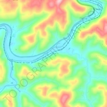
Nom : Carte topographique Calvin, altitude, relief.
Lieu : Calvin, Bell County, Kentucky, 40813, United States (36.70231 -83.64214 36.74231 -83.60214)
Altitude moyenne : 395 m
Altitude minimum : 304 m
Altitude maximum : 543 m
Autres cartes topographiques
Cliquez sur une carte pour visualiser sa topographie, son altitude et son relief.
Fourmile
United States > Kentucky > Bell County
Fourmile, Bell County, Kentucky, 40939, United States
Altitude moyenne : 406 m
Arjay
United States > Kentucky > Bell County
Arjay, Bell County, Kentucky, 40902, United States
Altitude moyenne : 464 m
Stoney Fork
United States > Kentucky > Bell County
Stoney Fork, Bell County, Kentucky, United States
Altitude moyenne : 519 m
Beverly
United States > Kentucky > Bell County
Beverly, Bell County, Kentucky, 40913, United States
Altitude moyenne : 526 m
Kettle Island
United States > Kentucky > Bell County
Kettle Island, Bell County, Kentucky, 40988, United States
Altitude moyenne : 469 m
Miracle
United States > Kentucky > Bell County
Miracle, Bell County, Kentucky, 40988, United States
Altitude moyenne : 413 m
Middlesborough
United States > Kentucky > Bell County
Middlesborough, Bell County, Kentucky, United States
Altitude moyenne : 406 m
Pineville
United States > Kentucky > Bell County
Pineville, Bell County, Kentucky, United States
Altitude moyenne : 426 m