
Carte topographique Frensdorf
Carte interactive
Cliquez sur la carte pour afficher l’altitude.
À propos de cette carte
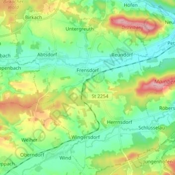
Nom : Carte topographique Frensdorf, altitude, relief.
Lieu : Frensdorf, Landkreis Bamberg, Bayern, 96158, Deutschland (49.77080 10.80947 49.84764 10.93347)
Altitude moyenne : 286 m
Altitude minimum : 243 m
Altitude maximum : 377 m
Autres cartes topographiques
Cliquez sur une carte pour visualiser sa topographie, son altitude et son relief.
Oberhaid
Deutschland > Bayern > Landkreis Bamberg
Oberhaid, Landkreis Bamberg, Bayern, 96173, Deutschland
Altitude moyenne : 275 m
Viereth-Trunstadt
Deutschland > Bayern > Landkreis Bamberg
Viereth-Trunstadt, Landkreis Bamberg, Bayern, 96191, Deutschland
Altitude moyenne : 288 m