
Carte topographique Porthcurno
Carte interactive
Cliquez sur la carte pour afficher l’altitude.
À propos de cette carte
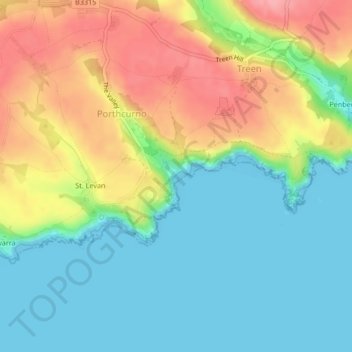
Nom : Carte topographique Porthcurno, altitude, relief.
Altitude moyenne : 39 m
Altitude minimum : 0 m
Altitude maximum : 101 m
Autres cartes topographiques
Cliquez sur une carte pour visualiser sa topographie, son altitude et son relief.
Levans Wall
United Kingdom > England > Cornwall > Porthcurno > St. Levan
Levans Wall, St. Levan, Porthcurno, Cornwall, England, TR19 6JT, United Kingdom
Altitude moyenne : 28 m