Géolocaliser

Carte topographique Linton

Carte interactive

Cliquez sur la carte pour afficher l’altitude.

À propos de cette carte

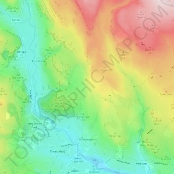
Nom : Carte topographique Linton, altitude, relief.

Lieu : Grassington, Linton, Craven, North Yorkshire, England, United Kingdom (54.05957 -2.03103 54.12641 -1.92510)

Altitude moyenne : 310 m

Altitude minimum : 153 m

Altitude maximum : 555 m

Autres cartes topographiques

Cliquez sur une carte pour visualiser sa topographie, son altitude et son relief.

Skipton

United Kingdom > England > North Yorkshire > Craven

Skipton, Craven, North Yorkshire, England, United Kingdom

Altitude moyenne : 173 m

Craven

United Kingdom > England > North Yorkshire > Craven

Craven, North Yorkshire, Yorkshire and the Humber, England, United Kingdom

Altitude moyenne : 294 m

Thornydale Laithe

United Kingdom > England > North Yorkshire > Craven > Calton

Thornydale Laithe, Calton, Craven, North Yorkshire, Yorkshire and the Humber, England, BD23 3QP, United Kingdom

Altitude moyenne : 179 m