Géolocaliser

Carte topographique 西秀区

Carte interactive

Cliquez sur la carte pour afficher l’altitude.

À propos de cette carte

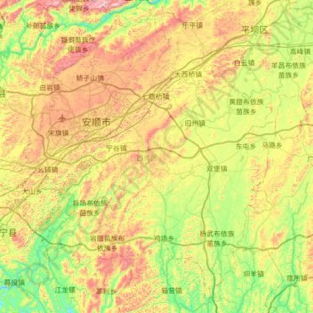
Nom : Carte topographique 西秀区, altitude, relief.

Lieu : 西秀区, 安顺市, 贵州省, 561000, 中国 (25.94019 105.74450 26.44236 106.35900)

Altitude moyenne : 1 322 m

Altitude minimum : 1 031 m

Altitude maximum : 1 805 m

Autres cartes topographiques

Cliquez sur une carte pour visualiser sa topographie, son altitude et son relief.

白水镇

中国 > 贵州省 > 安顺市

白水镇, 安顺市, 贵州省, 中国

Altitude moyenne : 1 043 m

乐平镇

中国 > 贵州省 > 安顺市

乐平镇, 安顺市, 贵州省, 中国

Altitude moyenne : 1 383 m

齐伯镇

中国 > 贵州省 > 安顺市

齐伯镇, 安顺市, 贵州省, 中国

Altitude moyenne : 1 279 m

双堡镇

中国 > 贵州省 > 安顺市

双堡镇, 安顺市, 贵州省, 中国

Altitude moyenne : 1 278 m

付家屯

中国 > 贵州省 > 安顺市

付家屯, 西秀区, 安顺市, 贵州省, 中国

Altitude moyenne : 1 371 m

普定县

中国 > 贵州省 > 安顺市

普定县, 安顺市, 贵州省, 中国

Altitude moyenne : 1 425 m

镇宁布依族苗族自治县

中国 > 贵州省 > 安顺市

镇宁布依族苗族自治县, 安顺市, 贵州省, 中国

Altitude moyenne : 1 139 m

关岭布依族苗族自治县

中国 > 贵州省 > 安顺市

关岭布依族苗族自治县, 安顺市, 贵州省, 中国

Altitude moyenne : 1 121 m

哑里

中国 > 贵州省 > 安顺市 > 哑里

哑里, 安顺市, 贵州省, 中国

Altitude moyenne : 1 527 m