
Faire un don
Équipez-vous pour votre prochaine aventure :
En tant que Partenaire Amazon, ce site perçoit une commission sur les achats éligibles sans surcoût pour vous.
Carte topographique Cerro Gigante
Cliquez sur la carte pour afficher l’altitude.
Faire un don
Équipez-vous pour votre prochaine aventure :
En tant que Partenaire Amazon, ce site perçoit une commission sur les achats éligibles sans surcoût pour vous.
À propos de cette carte
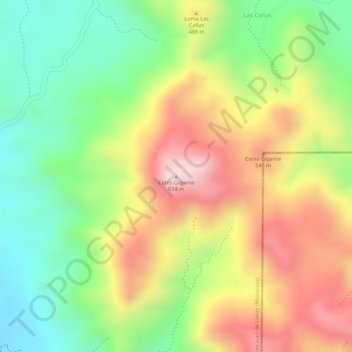
Nom : Carte topographique Cerro Gigante, altitude, relief.
Altitude moyenne : 420 m
Altitude minimum : 222 m
Altitude maximum : 636 m
Faire un don
Équipez-vous pour votre prochaine aventure :
En tant que Partenaire Amazon, ce site perçoit une commission sur les achats éligibles sans surcoût pour vous.
Autres cartes topographiques
Cliquez sur une carte pour visualiser sa topographie, son altitude et son relief.
Esteli
Located on the Pan-American Highway, 150 km north of Managua, Estelí is a fast-growing and progressive city. It enjoys a pleasant climate most of the year due to its location in the north central highlands at a mean elevation of 844 m (2769 ft) above sea level. The city is also surrounded by forested…
Altitude moyenne : 958 m
Condega (Municipio)
Condega (Spanish pronunciation: [konˈdeɣa]) is a municipality in the Estelí department of Nicaragua. It was officially incorporated on June 9, 1962. Condega is situated on the Pan-American Highway (Route One) at a distance of 185 kilometers north of Managua, and at an altitude of 560 meters (1,837 feet)…
Altitude moyenne : 836 m
Faire un don
Équipez-vous pour votre prochaine aventure :
En tant que Partenaire Amazon, ce site perçoit une commission sur les achats éligibles sans surcoût pour vous.