
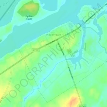
Carte topographique Village of Waddington
Carte interactive
Cliquez sur la carte pour afficher l’altitude.
À propos de cette carte
Nom : Carte topographique Village of Waddington, altitude, relief.
Altitude moyenne : 80 m
Altitude minimum : 69 m
Altitude maximum : 102 m
Autres cartes topographiques
Cliquez sur une carte pour visualiser sa topographie, son altitude et son relief.
Town of Massena
United States > New York > Saint Lawrence County
Town of Massena, Saint Lawrence County, New York, United States
Altitude moyenne : 70 m
Village of Potsdam
United States > New York > Saint Lawrence County > Town of Potsdam
Village of Potsdam, Town of Potsdam, Saint Lawrence County, New York, 13699, United States
Altitude moyenne : 133 m
Wildwood
United States > New York > Saint Lawrence County > Town of Colton
Wildwood, Town of Colton, Saint Lawrence County, New York, 13625, United States
Altitude moyenne : 306 m
Bear Mountain
United States > New York > Saint Lawrence County
Bear Mountain, Town of Clifton, Saint Lawrence County, New York, 12927, United States
Altitude moyenne : 504 m
Hermon
United States > New York > Saint Lawrence County > Hermon
Hermon, Saint Lawrence County, New York, 13652, United States
Altitude moyenne : 159 m