Carte topographique Salfords
Carte interactive
Cliquez sur la carte pour afficher l’altitude.
À propos de cette carte
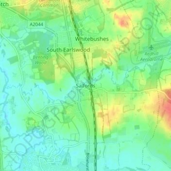
Autres cartes topographiques
Cliquez sur une carte pour visualiser sa topographie, son altitude et son relief.
Redhill
United Kingdom > England > Surrey > Reigate and Banstead
Redhill, Reigate and Banstead, Surrey, England, RH1 1RJ, United Kingdom
Altitude moyenne : 107 m
Nork Park
United Kingdom > England > Surrey > Reigate and Banstead > Banstead
Nork Park, Nork, Banstead, Reigate and Banstead, Surrey, England, KT18 5XE, United Kingdom
Altitude moyenne : 143 m
Burgh Heath
United Kingdom > England > Surrey > Reigate and Banstead
Burgh Heath, Reigate and Banstead, Surrey, England, KT20 5NJ, United Kingdom
Altitude moyenne : 143 m
Banstead Wood
United Kingdom > England > Surrey > Reigate and Banstead > Chipstead
Banstead Wood, Chipstead, Reigate and Banstead, Surrey, England, United Kingdom
Altitude moyenne : 145 m
St John's
United Kingdom > England > Surrey > Reigate and Banstead > Redhill
St John's, Meadvale, Redhill, Reigate and Banstead, Surrey, England, RH1 6QD, United Kingdom
Altitude moyenne : 87 m
Reigate
United Kingdom > England > Surrey > Reigate and Banstead
Reigate, Reigate and Banstead, Surrey, England, RH2 0AA, United Kingdom
Altitude moyenne : 100 m
Redhill Common
United Kingdom > England > Surrey > Reigate and Banstead > Redhill
Redhill Common, Meadvale, Redhill, Reigate and Banstead, Surrey, England, United Kingdom
Altitude moyenne : 92 m
Lower Kingswood
United Kingdom > England > Surrey > Reigate and Banstead
Lower Kingswood, Reigate and Banstead, Surrey, England, KT20 7AA, United Kingdom
Altitude moyenne : 170 m
Banstead
United Kingdom > England > Surrey > Reigate and Banstead
Banstead, Reigate and Banstead, Surrey, England, United Kingdom
Altitude moyenne : 142 m
Netherne-on-the-Hill
United Kingdom > England > Surrey > Reigate and Banstead
Netherne-on-the-Hill, Reigate and Banstead, Surrey, England, CR5 1NZ, United Kingdom
Altitude moyenne : 153 m
Reigate Hill
United Kingdom > England > Surrey > Reigate and Banstead
Reigate Hill, Reigate and Banstead, Surrey, England, RH2 9RN, United Kingdom
Altitude moyenne : 157 m
Lower Earlswood Lake
United Kingdom > England > Surrey > Reigate and Banstead > Redhill
Lower Earlswood Lake, Meadvale, Redhill, Reigate and Banstead, Surrey, South East England, England, United Kingdom
Altitude moyenne : 75 m
Norwood Hill
United Kingdom > England > Surrey > Reigate and Banstead > Norwood Hill
Norwood Hill, Reigate and Banstead, Surrey, South East England, England, RH6 0ET, United Kingdom
Altitude moyenne : 71 m
Tadworth
United Kingdom > England > Surrey > Reigate and Banstead
Tadworth, Reigate and Banstead, Surrey, England, KT20 5SW, United Kingdom
Altitude moyenne : 159 m
Horley
United Kingdom > England > Surrey > Reigate and Banstead
Horley, Reigate and Banstead, Surrey, England, United Kingdom
Altitude moyenne : 58 m