Carte topographique Killard
Carte interactive
Cliquez sur la carte pour afficher l’altitude.
À propos de cette carte
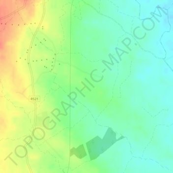
Autres cartes topographiques
Cliquez sur une carte pour visualiser sa topographie, son altitude et son relief.
Churchtown
Ireland > County Limerick > The Municipal District of Newcastle West
Churchtown, Newcastle Urban, The Municipal District of Newcastle West, County Limerick, Munster, V42 P682, Ireland
Altitude moyenne : 66 m
Knockawarriga
Ireland > County Limerick > The Municipal District of Newcastle West
Knockawarriga, The Municipal District of Newcastle West, County Limerick, Munster, Ireland
Altitude moyenne : 247 m
Athea
Ireland > County Limerick > The Municipal District of Newcastle West
Athea, The Municipal District of Newcastle West, County Limerick, Munster, Ireland
Altitude moyenne : 114 m
Newcastle
Ireland > County Limerick > The Municipal District of Newcastle West
Newcastle, The Municipal District of Newcastle West, County Limerick, Munster, V42 P682, Ireland
Altitude moyenne : 92 m
Caheragh
Ireland > County Limerick > The Municipal District of Newcastle West
Caheragh, Glin, The Municipal District of Newcastle West, County Limerick, Munster, Ireland
Altitude moyenne : 26 m
Crataloe East
Ireland > County Limerick > The Municipal District of Newcastle West
Crataloe East, Rathronan, The Municipal District of Newcastle West, County Limerick, Munster, Ireland
Altitude moyenne : 184 m
Crataloe West
Ireland > County Limerick > The Municipal District of Newcastle West
Crataloe West, Rathronan, The Municipal District of Newcastle West, County Limerick, Munster, Ireland
Altitude moyenne : 153 m
Ballaghbehy
Ireland > County Limerick > The Municipal District of Newcastle West
Ballaghbehy, Dromtrasna, The Municipal District of Newcastle West, County Limerick, Munster, Ireland
Altitude moyenne : 135 m
Coolacokery
Ireland > County Limerick > The Municipal District of Newcastle West
Coolacokery, Ardagh ED, The Municipal District of Newcastle West, County Limerick, Munster, Ireland
Altitude moyenne : 52 m