
Faire un don
Équipez-vous pour votre prochaine aventure :
En tant que Partenaire Amazon, ce site perçoit une commission sur les achats éligibles sans surcoût pour vous.
Carte topographique Kula
Cliquez sur la carte pour afficher l’altitude.
Faire un don
Équipez-vous pour votre prochaine aventure :
En tant que Partenaire Amazon, ce site perçoit une commission sur les achats éligibles sans surcoût pour vous.
Kula
Kula is a district and census-designated place (CDP) of Maui, Hawaii, that stretches across the "up-country", the western-facing slopes of Haleakalā, from Makawao to Kanaio. Most of the residential areas lie between about 500 to 1,100 m (1,600 to 3,600 ft) in elevation. The district has traditionally been where full-time residents prefer to live, as distinct from the generally hotter and busier, more tourism-oriented towns near sea level, such as Kihei and Lahaina. The population of the Kula CDP at the 2020 Census was 6,942, while the larger Kula Census County Division, which includes the communities of Keokea, Wailea, and Makena, had a population of 12,864.
Faire un don
Équipez-vous pour votre prochaine aventure :
En tant que Partenaire Amazon, ce site perçoit une commission sur les achats éligibles sans surcoût pour vous.
À propos de cette carte
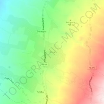
Nom : Carte topographique Kula, altitude, relief.
Lieu : Kula, Maui County, Hawaii, United States (20.77203 -156.34371 20.81203 -156.30371)
Altitude moyenne : 740 m
Altitude minimum : 473 m
Altitude maximum : 1 089 m
Faire un don
Équipez-vous pour votre prochaine aventure :
En tant que Partenaire Amazon, ce site perçoit une commission sur les achats éligibles sans surcoût pour vous.
Autres cartes topographiques
Cliquez sur une carte pour visualiser sa topographie, son altitude et son relief.
Maui
United States > Hawaii > Maui County
Maui County's topography is characterized by a dramatic blend of volcanic mountains, rolling hills, and stunning coastal regions, creating a diverse landscape that contributes to its unique beauty. The island's centerpiece is Haleakalā, a massive shield volcano rising to an elevation of 10,023 feet, which is…
Altitude moyenne : 232 m
Molokai
United States > Hawaii > Maui County
The eastern half of the island is a high plateau rising up to an elevation of 4,900 ft (1,500 m) on Kamakou peak and includes the 2,774 acres (11.23 km2; 4.334 sq mi) Molokaʻi Forest Reserve. The eastern half is covered with lush wet forests that get more than 300 in (7,600 mm) of rain per year. The…
Altitude moyenne : 66 m
Faire un don
Équipez-vous pour votre prochaine aventure :
En tant que Partenaire Amazon, ce site perçoit une commission sur les achats éligibles sans surcoût pour vous.
Faire un don
Équipez-vous pour votre prochaine aventure :
En tant que Partenaire Amazon, ce site perçoit une commission sur les achats éligibles sans surcoût pour vous.
Haleakalā National Park
United States > Hawaii > Maui County
At its lowest, near the ocean, the National Park has a tropical rainforest climate bordering a tropical monsoon climate. However, as altitudes progresses the climate becomes oceanic/Mediterranean, reaching, at the very top of Haleakalā, an alpine climate.
Altitude moyenne : 949 m
Lānaʻi
United States > Hawaii > Maui County
The highest point in Lanai is Mount Lānaʻihale. It is an inactive volcano near the center of the island and to the east of Lanai City. The elevation of Mount Lānaʻihale is 3,366 ft (1,026 m).
Altitude moyenne : 162 m
Faire un don
Équipez-vous pour votre prochaine aventure :
En tant que Partenaire Amazon, ce site perçoit une commission sur les achats éligibles sans surcoût pour vous.
Maui
United States > Hawaii > Maui County
Maui's diverse landscapes are the result of a unique combination of geology, topography, and climate. Each volcanic cone in the chain of the Hawaiian Islands is built of dark, iron-rich/quartz-poor rocks, which poured out of thousands of vents as highly fluid lava throughout millions of years. Several of the…
Altitude moyenne : 232 m
Faire un don
Équipez-vous pour votre prochaine aventure :
En tant que Partenaire Amazon, ce site perçoit une commission sur les achats éligibles sans surcoût pour vous.
Maui
United States > Hawaii > Maui County
The climate is characterized by a two-season year, tropical and uniform temperatures at any given elevation, geographic differences in rainfall, high relative humidity, extensive cloud formations (except on the leeward coasts and at the highest elevations), and dominant trade wind flow (especially at lower…
Altitude moyenne : 232 m
Molokai
United States > Hawaii > Maui County
The eastern half of the island is a high plateau rising up to an elevation of 4,900 ft (1,500 m) on Kamakou peak and includes the 2,774-acre (11.23 km2; 4.334 mi2) Molokai Forest Reserve. The eastern half is covered with lush wet forests that get more than 300 in (7,600 mm) of rain per year. The high-elevation…
Altitude moyenne : 66 m
Faire un don
Équipez-vous pour votre prochaine aventure :
En tant que Partenaire Amazon, ce site perçoit une commission sur les achats éligibles sans surcoût pour vous.
Haleakalā National Park
United States > Hawaii > Maui County
At its lowest, near the ocean, the National Park has a tropical rainforest climate bordering a tropical monsoon climate. However, as altitudes progresses the climate becomes oceanic/Mediterranean, reaching, at the very top of Haleakalā, an alpine climate.
Altitude moyenne : 949 m
Molokini Shoal Marine Life Conservation District
United States > Hawaii > Maui County
Altitude moyenne : 0 m
Faire un don
Équipez-vous pour votre prochaine aventure :
En tant que Partenaire Amazon, ce site perçoit une commission sur les achats éligibles sans surcoût pour vous.
Maui
United States > Hawaii > Maui County
Maui's diverse landscapes are the result of a unique combination of geology, topography, and climate. Each volcanic cone in the chain of the Hawaiian Islands is built of dark, iron-rich/quartz-poor rocks, which poured out of thousands of vents as highly fluid lava throughout millions of years. Several of the…
Altitude moyenne : 232 m
Faire un don
Équipez-vous pour votre prochaine aventure :
En tant que Partenaire Amazon, ce site perçoit une commission sur les achats éligibles sans surcoût pour vous.
Lānaʻi
United States > Hawaii > Maui County
The highest point in Lanai is Mount Lānaʻihale. It is an inactive volcano near the center of the island and to the east of Lanai City. The elevation of Mount Lānaʻihale is 3,366 ft (1,026 m).
Altitude moyenne : 162 m
Lānaʻi
United States > Hawaii > Maui County
The highest point in Lanai is Mount Lānaʻihale. It is an inactive volcano near the center of the island and to the east of Lanai City. The elevation of Mount Lānaʻihale is 3,366 ft (1,026 m).
Altitude moyenne : 162 m
Faire un don
Équipez-vous pour votre prochaine aventure :
En tant que Partenaire Amazon, ce site perçoit une commission sur les achats éligibles sans surcoût pour vous.