
Faire un don
Équipez-vous pour votre prochaine aventure :
En tant que Partenaire Amazon, ce site perçoit une commission sur les achats éligibles sans surcoût pour vous.
Carte topographique Chemult
Cliquez sur la carte pour afficher l’altitude.
Faire un don
Équipez-vous pour votre prochaine aventure :
En tant que Partenaire Amazon, ce site perçoit une commission sur les achats éligibles sans surcoût pour vous.
À propos de cette carte
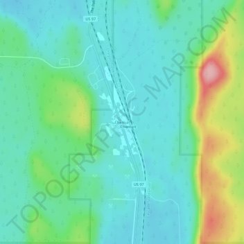
Nom : Carte topographique Chemult, altitude, relief.
Lieu : Chemult, Klamath County, Oregon, United States (43.19652 -121.80280 43.23652 -121.76280)
Altitude moyenne : 1 480 m
Altitude minimum : 1 440 m
Altitude maximum : 1 601 m
Faire un don
Équipez-vous pour votre prochaine aventure :
En tant que Partenaire Amazon, ce site perçoit une commission sur les achats éligibles sans surcoût pour vous.
Autres cartes topographiques
Cliquez sur une carte pour visualiser sa topographie, son altitude et son relief.
Merrill
United States > Oregon > Klamath County
Merrill is at an elevation of 4,071 feet (1,241 m) in southern Klamath County, near the Oregon–California border. It is along Oregon Route 39 southeast of Klamath Falls and northwest of Tulelake. Lower Klamath Lake and Tule Lake, both in California, are slightly south of Merrill. By highway, the city is 20…
Altitude moyenne : 1 241 m
Malin
United States > Oregon > Klamath County
Malin is at an elevation of 4,062 feet (1,238 m) in southern Klamath County near the Oregon–California border. It is along a spur of Oregon Route 39, southeast of Klamath Falls, east of Merrill, and northeast of Tulelake. Lava Beds National Monument is to the south, nearby in California. By highway, the city…
Altitude moyenne : 1 241 m
Faire un don
Équipez-vous pour votre prochaine aventure :
En tant que Partenaire Amazon, ce site perçoit une commission sur les achats éligibles sans surcoût pour vous.