
Faire un don
Équipez-vous pour votre prochaine aventure :
En tant que Partenaire Amazon, ce site perçoit une commission sur les achats éligibles sans surcoût pour vous.
Carte topographique Ocean Shores
Cliquez sur la carte pour afficher l’altitude.
Faire un don
Équipez-vous pour votre prochaine aventure :
En tant que Partenaire Amazon, ce site perçoit une commission sur les achats éligibles sans surcoût pour vous.
Ocean Shores
Ocean Shores is set on relatively flat coastal terrain. The city's elevation averages about 10 to 15 feet (3 to 5 meters) above sea level, typical for much of the Washington coast's beach communities. It sits on a spit of land between the Pacific Ocean to the west and Grays Harbor to the east. This unique location features extensive sandy beaches, dunes, and marshlands that support diverse ecosystems. The surrounding area includes low-lying tidal flats and coastal wetlands, contributing to the region's dynamic and frequently shifting landscape. Additionally, the terrain is marked by shallow bays and rivers that further shape the coastal environment, creating a scenic but vulnerable coastal zone.
Faire un don
Équipez-vous pour votre prochaine aventure :
En tant que Partenaire Amazon, ce site perçoit une commission sur les achats éligibles sans surcoût pour vous.
À propos de cette carte
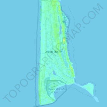
Nom : Carte topographique Ocean Shores, altitude, relief.
Altitude moyenne : 1 m
Altitude minimum : -2 m
Altitude maximum : 19 m
Faire un don
Équipez-vous pour votre prochaine aventure :
En tant que Partenaire Amazon, ce site perçoit une commission sur les achats éligibles sans surcoût pour vous.
Autres cartes topographiques
Cliquez sur une carte pour visualiser sa topographie, son altitude et son relief.
Faire un don
Équipez-vous pour votre prochaine aventure :
En tant que Partenaire Amazon, ce site perçoit une commission sur les achats éligibles sans surcoût pour vous.
Roosevelt Beach Conservation Area
United States > Washington > Grays Harbor County > Ocean Grove
Altitude moyenne : 18 m
Faire un don
Équipez-vous pour votre prochaine aventure :
En tant que Partenaire Amazon, ce site perçoit une commission sur les achats éligibles sans surcoût pour vous.
Roosevelt Beach Conservation Area
United States > Washington > Grays Harbor County > Ocean Grove
Altitude moyenne : 18 m
Faire un don
Équipez-vous pour votre prochaine aventure :
En tant que Partenaire Amazon, ce site perçoit une commission sur les achats éligibles sans surcoût pour vous.
McCleary
United States > Washington > Grays Harbor County > McCleary > McCleary
Altitude moyenne : 108 m