
Faire un don
Équipez-vous pour votre prochaine aventure :
En tant que Partenaire Amazon, ce site perçoit une commission sur les achats éligibles sans surcoût pour vous.
Carte topographique Flowing Wells
Cliquez sur la carte pour afficher l’altitude.
Faire un don
Équipez-vous pour votre prochaine aventure :
En tant que Partenaire Amazon, ce site perçoit une commission sur les achats éligibles sans surcoût pour vous.
À propos de cette carte
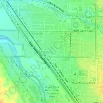
Nom : Carte topographique Flowing Wells, altitude, relief.
Lieu : Flowing Wells, Jaynes, Pima County, Arizona, United States (32.28160 -111.04103 32.30997 -111.01770)
Altitude moyenne : 687 m
Altitude minimum : 674 m
Altitude maximum : 705 m
Faire un don
Équipez-vous pour votre prochaine aventure :
En tant que Partenaire Amazon, ce site perçoit une commission sur les achats éligibles sans surcoût pour vous.
Autres cartes topographiques
Cliquez sur une carte pour visualiser sa topographie, son altitude et son relief.
Tucson
United States > Arizona > Pima County
Tucson is situated on an alluvial plain in the Sonoran Desert, at an elevation of approximately 2,400 feet (730 meters) above sea level. The city is enveloped by five mountain ranges, which contribute significantly to its varied topography. To the north lie the Santa Catalina and Tortolita Mountains, while the…
Altitude moyenne : 822 m
Tucson
United States > Arizona > Pima County
By 1900, 7,531 people lived in Tucson. By 1910, the population increased to 13,913. At about this time, the U.S. Veterans Administration had begun construction of the present Veterans Hospital. The city's clean, dry air made it a destination for the many veterans who had been gassed in World War I and needed…
Altitude moyenne : 822 m
Oro Valley
United States > Arizona > Pima County
Oro Valley is located at 32°25′N 110°59′W / 32.417°N 110.983°W / 32.417; -110.983 (32.4212, −110.9760) in the middle Cañada del Oro Valley. Oro Valley sits at an average elevation of 2,620 feet (800 m) above sea level.
Altitude moyenne : 969 m
Faire un don
Équipez-vous pour votre prochaine aventure :
En tant que Partenaire Amazon, ce site perçoit une commission sur les achats éligibles sans surcoût pour vous.
Saguaro National Park
United States > Arizona > Pima County
Both districts conserve tracts of the Sonoran Desert, including ranges of significant hills, the Tucson Mountains in the west and the Rincon Mountains in the east. Elevations in the Tucson Mountain District range from 2,180 to 4,687 feet (664 to 1,429 m), the summit of Wasson Peak. Elevations within the Rincon…
Altitude moyenne : 1 174 m
Catalina State Park
United States > Arizona > Pima County
Catalina State Park is located at the base of the Santa Catalina Mountains. It is home to nearly 5,000 saguaros and desert plants. There are 5,500 acres of foothills and canyons that offer opportunities for camping, hiking, and bird watching. The park is home to more than 150 species. At an elevation of nearly…
Altitude moyenne : 906 m
Faire un don
Équipez-vous pour votre prochaine aventure :
En tant que Partenaire Amazon, ce site perçoit une commission sur les achats éligibles sans surcoût pour vous.
Marana
United States > Arizona > Pima County
Marana has a hot semi-arid climate (Köppen climate classification BSh). This is characterized by hot summers and relatively mild winters. The area averages only 12.19 inches (310 mm) of annual rainfall. During the dry and sunny winter months, daytime highs usually reach between 60°F and 70°F (16°C and…
Altitude moyenne : 657 m
Faire un don
Équipez-vous pour votre prochaine aventure :
En tant que Partenaire Amazon, ce site perçoit une commission sur les achats éligibles sans surcoût pour vous.
Faire un don
Équipez-vous pour votre prochaine aventure :
En tant que Partenaire Amazon, ce site perçoit une commission sur les achats éligibles sans surcoût pour vous.
Faire un don
Équipez-vous pour votre prochaine aventure :
En tant que Partenaire Amazon, ce site perçoit une commission sur les achats éligibles sans surcoût pour vous.
Marana
United States > Arizona > Pima County
Marana has a hot semi-arid climate (Köppen climate classification BSh). This is characterized by hot summers and relatively mild winters. The area averages only 12.19 inches (310 mm) of annual rainfall. During the dry and sunny winter months, daytime highs usually reach between 60°F and 70°F (16°C and…
Altitude moyenne : 660 m
Saguaro National Park
United States > Arizona > Pima County
Both districts conserve tracts of the Sonoran Desert, including ranges of significant hills, the Tucson Mountains in the west and the Rincon Mountains in the east. Elevations in the Tucson Mountain District range from 2,180 to 4,687 feet (664 to 1,429 m), the summit of Wasson Peak. Elevations within the Rincon…
Altitude moyenne : 1 174 m
Faire un don
Équipez-vous pour votre prochaine aventure :
En tant que Partenaire Amazon, ce site perçoit une commission sur les achats éligibles sans surcoût pour vous.
Saguaro National Park
United States > Arizona > Pima County
Both districts conserve tracts of the Sonoran Desert, including ranges of significant hills, the Tucson Mountains in the west and the Rincon Mountains in the east. Elevations in the Tucson Mountain District range from 2,180 to 4,687 feet (664 to 1,429 m), the summit of Wasson Peak. Elevations within the Rincon…
Altitude moyenne : 1 174 m
Tucson
United States > Arizona > Pima County > Tucson
The city's elevation is 2,643 ft (806 m) above sea level (as measured at the Tucson International Airport). Tucson is on an alluvial plain in the Sonoran Desert, surrounded by five minor ranges of mountains: the Santa Catalina Mountains and the Tortolita Mountains to the north, the Santa Rita Mountains to the…
Altitude moyenne : 836 m
Faire un don
Équipez-vous pour votre prochaine aventure :
En tant que Partenaire Amazon, ce site perçoit une commission sur les achats éligibles sans surcoût pour vous.
Oro Valley
United States > Arizona > Pima County
Oro Valley is located at 32°25′N 110°59′W / 32.417°N 110.983°W / 32.417; -110.983 (32.4212, −110.9760) in the middle Cañada del Oro Valley. Oro Valley sits at an average elevation of 2,620 feet (800 m) above sea level.
Altitude moyenne : 969 m
Faire un don
Équipez-vous pour votre prochaine aventure :
En tant que Partenaire Amazon, ce site perçoit une commission sur les achats éligibles sans surcoût pour vous.
Marana
United States > Arizona > Pima County
Marana has a hot semi-arid climate (Köppen climate classification BSh). This is characterized by hot summers and relatively mild winters. The area averages only 12.19 inches (310 mm) of annual rainfall. During the dry and sunny winter months, daytime highs usually reach between 60 and 70 °F (16 and 21 °C),…
Altitude moyenne : 660 m
Oro Valley
United States > Arizona > Pima County
Oro Valley is located at 32°25′N 110°59′W / 32.417°N 110.983°W / 32.417; -110.983 (32.4212, −110.9760) in the middle of the Cañada del Oro Valley. Oro Valley sits at an average elevation of 2,620 feet (800 m) above sea level.
Altitude moyenne : 969 m
Faire un don
Équipez-vous pour votre prochaine aventure :
En tant que Partenaire Amazon, ce site perçoit une commission sur les achats éligibles sans surcoût pour vous.
Tucson
United States > Arizona > Pima County
By 1900, Tucson had 7,531 residents. By 1910, the population increased to 13,913. About this time, the U.S. Veterans Administration had begun construction of the present Veterans Hospital. The city's clean, dry air made it a destination for many veterans who had been gassed in World War I and needed…
Altitude moyenne : 822 m
Tucson
United States > Arizona > Pima County
By 1900, 7,531 people lived in Tucson. By 1910, the population increased to 13,913. About this time, the U.S. Veterans Administration had begun construction of the present Veterans Hospital. The city's clean, dry air made it a destination for many veterans who had been gassed in World War I and needed…
Altitude moyenne : 822 m
Faire un don
Équipez-vous pour votre prochaine aventure :
En tant que Partenaire Amazon, ce site perçoit une commission sur les achats éligibles sans surcoût pour vous.
Oro Valley
United States > Arizona > Pima County
Oro Valley is located at 32°25′N 110°59′W / 32.417°N 110.983°W / 32.417; -110.983 (32.4212, −110.9760) in the middle of the Cañada del Oro Valley. Oro Valley sits at an average elevation of 2,620 feet (800 m) above sea level.
Altitude moyenne : 969 m
Faire un don
Équipez-vous pour votre prochaine aventure :
En tant que Partenaire Amazon, ce site perçoit une commission sur les achats éligibles sans surcoût pour vous.
Saguaro National Park
United States > Arizona > Pima County
Both districts conserve tracts of the Sonoran Desert, including ranges of significant hills, the Tucson Mountains in the west and the Rincon Mountains in the east. Elevations in the Tucson Mountain District range from 2,180 to 4,687 feet (664 to 1,429 m), the summit of Wasson Peak. Elevations within the Rincon…
Altitude moyenne : 1 174 m
Tucson
United States > Arizona > Pima County
By 1900, 7,531 people lived in Tucson. By 1910, the population increased to 13,913. About this time, the U.S. Veterans Administration had begun construction of the present Veterans Hospital. The city's clean, dry air made it a destination for many veterans who had been gassed in World War I and needed…
Altitude moyenne : 822 m
Faire un don
Équipez-vous pour votre prochaine aventure :
En tant que Partenaire Amazon, ce site perçoit une commission sur les achats éligibles sans surcoût pour vous.