
Faire un don
Équipez-vous pour votre prochaine aventure :
En tant que Partenaire Amazon, ce site perçoit une commission sur les achats éligibles sans surcoût pour vous.
Carte topographique University Park
Cliquez sur la carte pour afficher l’altitude.
Faire un don
Équipez-vous pour votre prochaine aventure :
En tant que Partenaire Amazon, ce site perçoit une commission sur les achats éligibles sans surcoût pour vous.
University Park
University Park was developed on land owned by the Deakins family since the mid-1700s. The house known as Deakins Hall or Bloomfield was constructed on the land in the 1820s or 1830s. It is located at 6404 Queens Chapel Road. The farm was purchased by the University Park Company in 1923. The extension of water and sewer lines into area at that time prompted the subdivision of the Deakins tract. The developers promised a community of single-family homes without the intrusion of commercial facilities. Restrictive covenants were placed on the deeds and all house plans had to be approved by the developers. Homebuyers were attracted to University Park due to its high elevation and lush vegetation. The developers also agreed to provide streetlights and trash removal for a 10-year period, and constructed a school in the mid-1920s.
Faire un don
Équipez-vous pour votre prochaine aventure :
En tant que Partenaire Amazon, ce site perçoit une commission sur les achats éligibles sans surcoût pour vous.
À propos de cette carte
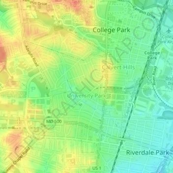
Nom : Carte topographique University Park, altitude, relief.
Altitude moyenne : 29 m
Altitude minimum : 5 m
Altitude maximum : 57 m
Faire un don
Équipez-vous pour votre prochaine aventure :
En tant que Partenaire Amazon, ce site perçoit une commission sur les achats éligibles sans surcoût pour vous.