
Faire un don
Équipez-vous pour votre prochaine aventure :
En tant que Partenaire Amazon, ce site perçoit une commission sur les achats éligibles sans surcoût pour vous.
Carte topographique Cherry Log
Cliquez sur la carte pour afficher l’altitude.
Faire un don
Équipez-vous pour votre prochaine aventure :
En tant que Partenaire Amazon, ce site perçoit une commission sur les achats éligibles sans surcoût pour vous.
À propos de cette carte
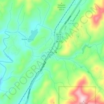
Nom : Carte topographique Cherry Log, altitude, relief.
Lieu : Cherry Log, Gilmer County, Georgia, 30522, United States (34.76036 -84.41076 34.80036 -84.37076)
Altitude moyenne : 522 m
Altitude minimum : 422 m
Altitude maximum : 728 m
Faire un don
Équipez-vous pour votre prochaine aventure :
En tant que Partenaire Amazon, ce site perçoit une commission sur les achats éligibles sans surcoût pour vous.
Autres cartes topographiques
Cliquez sur une carte pour visualiser sa topographie, son altitude et son relief.
Ellijay
United States > Georgia > Gilmer County
Ellijay sits within a rugged and mountainous terrain, characterized by rolling hills, deep valleys, and ridgelines that are part of the larger Appalachian Mountain system. The area has an average elevation of about 1,390 feet, though nearby peaks like Walnut Mountain rise to elevations over 2,500 feet. The…
Altitude moyenne : 424 m
Faire un don
Équipez-vous pour votre prochaine aventure :
En tant que Partenaire Amazon, ce site perçoit une commission sur les achats éligibles sans surcoût pour vous.
Ellijay
United States > Georgia > Gilmer County
Ellijay lies within the Humid subtropical climate zone along with the majority of the rest of the Southeastern United States. The highest elevations in the surrounding region reside in the oceanic climate. Ellijay enjoys cool winters and warm summers, but neither would be considered extreme due to its slightly…
Altitude moyenne : 424 m
Ellijay
United States > Georgia > Gilmer County
Ellijay lies within the Humid subtropical climate zone along with the majority of the rest of the southeastern United States. The highest elevations in the surrounding region reside in the Subtropical highland climate. Ellijay enjoys cool winters and warm summers, but neither would be considered extreme thanks…
Altitude moyenne : 424 m