
Faire un don
Équipez-vous pour votre prochaine aventure :
En tant que Partenaire Amazon, ce site perçoit une commission sur les achats éligibles sans surcoût pour vous.
Carte topographique Collbran
Cliquez sur la carte pour afficher l’altitude.
Faire un don
Équipez-vous pour votre prochaine aventure :
En tant que Partenaire Amazon, ce site perçoit une commission sur les achats éligibles sans surcoût pour vous.
À propos de cette carte
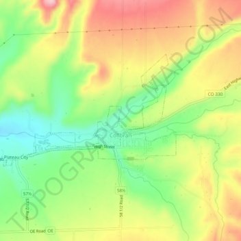
Nom : Carte topographique Collbran, altitude, relief.
Lieu : Collbran, Mesa County, Colorado, United States (39.23259 -107.99765 39.25288 -107.95030)
Altitude moyenne : 1 882 m
Altitude minimum : 1 788 m
Altitude maximum : 1 987 m
Faire un don
Équipez-vous pour votre prochaine aventure :
En tant que Partenaire Amazon, ce site perçoit une commission sur les achats éligibles sans surcoût pour vous.
Autres cartes topographiques
Cliquez sur une carte pour visualiser sa topographie, son altitude et son relief.
Grand Mesa
United States > Colorado > Mesa County
The Grand Mesa is a large mesa in western Colorado in the United States. It is the largest flat-topped mountain in the world. It has an area of about 500 square miles (1,300 km2) and stretches for about 40 miles (60 km) east of Grand Junction between the Colorado River and the Gunnison River, its tributary to…
Altitude moyenne : 2 666 m
Colorado River
United States > Colorado > Mesa County > Clifton
The entire eastern boundary of the Colorado River Basin runs along the North American Continental Divide and is defined largely by the Rocky Mountains and the Rio Grande Basin. The Wind River Range in Wyoming marks the northern extent of the basin, and is separated from the Colorado Rockies by the endorheic…
Altitude moyenne : 1 417 m
Faire un don
Équipez-vous pour votre prochaine aventure :
En tant que Partenaire Amazon, ce site perçoit une commission sur les achats éligibles sans surcoût pour vous.
Grand Mesa
United States > Colorado > Mesa County
The Grand Mesa is a large mesa in western Colorado in the United States. It is the largest flat-topped mountain in the world. It has an area of about 500 square miles (1,300 km2) and stretches for about 40 miles (64 km) east of Grand Junction between the Colorado River and the Gunnison River, its tributary to…
Altitude moyenne : 2 666 m
Faire un don
Équipez-vous pour votre prochaine aventure :
En tant que Partenaire Amazon, ce site perçoit une commission sur les achats éligibles sans surcoût pour vous.
Faire un don
Équipez-vous pour votre prochaine aventure :
En tant que Partenaire Amazon, ce site perçoit une commission sur les achats éligibles sans surcoût pour vous.
Colorado River
United States > Colorado > Mesa County
The entire eastern boundary of the Colorado River Basin runs along the North American Continental Divide and is defined largely by the Rocky Mountains and the Rio Grande Basin. The Wind River Range in Wyoming marks the northern extent of the basin, and is separated from the Colorado Rockies by the endorheic…
Altitude moyenne : 1 417 m