
Faire un don
Équipez-vous pour votre prochaine aventure :
En tant que Partenaire Amazon, ce site perçoit une commission sur les achats éligibles sans surcoût pour vous.
Carte topographique Adapalli
Cliquez sur la carte pour afficher l’altitude.
Faire un don
Équipez-vous pour votre prochaine aventure :
En tant que Partenaire Amazon, ce site perçoit une commission sur les achats éligibles sans surcoût pour vous.
À propos de cette carte
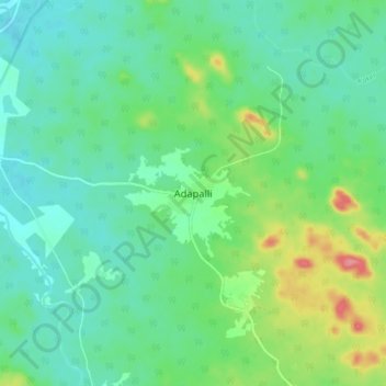
Nom : Carte topographique Adapalli, altitude, relief.
Lieu : Adapalli, Bijapur, Chhattisgarh, India (19.11500 80.40809 19.19500 80.48809)
Altitude moyenne : 197 m
Altitude minimum : 172 m
Altitude maximum : 263 m
Faire un don
Équipez-vous pour votre prochaine aventure :
En tant que Partenaire Amazon, ce site perçoit une commission sur les achats éligibles sans surcoût pour vous.
Autres cartes topographiques
Cliquez sur une carte pour visualiser sa topographie, son altitude et son relief.
Faire un don
Équipez-vous pour votre prochaine aventure :
En tant que Partenaire Amazon, ce site perçoit une commission sur les achats éligibles sans surcoût pour vous.
Jashpur
Major rivers in the Mahanadi basin are Ib and its tributaries such as Dorki, Maini, Kokiya, Utai, Khadung, Girma and Burhi. In the eastern part, rivers named Baki and Lava Nadi flow in the Brahmani basin. Lower Ganges part is mainly drained by Geor and Kanhar rivers. The drainage pattern is dendritic and is…
Altitude moyenne : 603 m
Faire un don
Équipez-vous pour votre prochaine aventure :
En tant que Partenaire Amazon, ce site perçoit une commission sur les achats éligibles sans surcoût pour vous.
Sukma
This place can easily be a matter of research for the Archaeological department as there exists rare ancient sculptures in this area, one can see a sculpture on which Brahma,Vishnu and Mahesh the Trinity of Hindu faith can be seen on a single stone. Now with the elevation of this area into a new District…
Altitude moyenne : 256 m
Faire un don
Équipez-vous pour votre prochaine aventure :
En tant que Partenaire Amazon, ce site perçoit une commission sur les achats éligibles sans surcoût pour vous.
Surajpur
Due to its mountainous topography, the district largely escaped the turmoil of the surrounding plains. The earliest inhabitants are said to be the Kols and Gonds, but there is evidence of more widespread civilization in the region. The rulers of Surguja State were Raksel Rajputs, and were said to have…
Altitude moyenne : 572 m
Faire un don
Équipez-vous pour votre prochaine aventure :
En tant que Partenaire Amazon, ce site perçoit une commission sur les achats éligibles sans surcoût pour vous.
Faire un don
Équipez-vous pour votre prochaine aventure :
En tant que Partenaire Amazon, ce site perçoit une commission sur les achats éligibles sans surcoût pour vous.
Faire un don
Équipez-vous pour votre prochaine aventure :
En tant que Partenaire Amazon, ce site perçoit une commission sur les achats éligibles sans surcoût pour vous.
Faire un don
Équipez-vous pour votre prochaine aventure :
En tant que Partenaire Amazon, ce site perçoit une commission sur les achats éligibles sans surcoût pour vous.
Faire un don
Équipez-vous pour votre prochaine aventure :
En tant que Partenaire Amazon, ce site perçoit une commission sur les achats éligibles sans surcoût pour vous.
Surguja
In Surguja bauxite deposits have been found in tertiary rocks. Due to decay and weathering of aluminium rich rocks, felspar usually kaolinised under tropical monsoon conditions, the weathering goes a step further and results in a residue rich in hydroxides of aluminium together with oxides of iron, manganese…
Altitude moyenne : 619 m
Faire un don
Équipez-vous pour votre prochaine aventure :
En tant que Partenaire Amazon, ce site perçoit une commission sur les achats éligibles sans surcoût pour vous.
Faire un don
Équipez-vous pour votre prochaine aventure :
En tant que Partenaire Amazon, ce site perçoit une commission sur les achats éligibles sans surcoût pour vous.
Koriya
Koriya District lies between 22°56′ and 23°48′ North and 81°56′ and 82°47′ East. It is bounded on the north-west by Manendragarh-Chirmiri-Bharatpur district, on the south by Korba District, on the east by Surajpur District. The area of the district is 5977 km2, of which 59.9% is forest area. The…
Altitude moyenne : 609 m
Faire un don
Équipez-vous pour votre prochaine aventure :
En tant que Partenaire Amazon, ce site perçoit une commission sur les achats éligibles sans surcoût pour vous.
Faire un don
Équipez-vous pour votre prochaine aventure :
En tant que Partenaire Amazon, ce site perçoit une commission sur les achats éligibles sans surcoût pour vous.
Raigarh
India > Chhattisgarh > Raigarh Tahsil
Raigarh is located at 21°54′N 83°24′E / 21.9°N 83.4°E / 21.9; 83.4. It has an average elevation of 215 metres (705 feet). The Kelo river flows through the city, which is one of its main water sources.
Altitude moyenne : 216 m
Faire un don
Équipez-vous pour votre prochaine aventure :
En tant que Partenaire Amazon, ce site perçoit une commission sur les achats éligibles sans surcoût pour vous.
Faire un don
Équipez-vous pour votre prochaine aventure :
En tant que Partenaire Amazon, ce site perçoit une commission sur les achats éligibles sans surcoût pour vous.
Faire un don
Équipez-vous pour votre prochaine aventure :
En tant que Partenaire Amazon, ce site perçoit une commission sur les achats éligibles sans surcoût pour vous.
Jashpur
Major rivers in the Mahanadi basin are Ib and its tributaries such as Dorki, Maini, Kokiya, Utai, Khadung, and Burhi. In the eastern part, rivers named Girma and Lava Nadi flow in the Brahmani basin. Lower Ganges part is mainly drained by Geor and Kanhar rivers. The drainage pattern is dendritic and is highly…
Altitude moyenne : 603 m
Faire un don
Équipez-vous pour votre prochaine aventure :
En tant que Partenaire Amazon, ce site perçoit une commission sur les achats éligibles sans surcoût pour vous.
Faire un don
Équipez-vous pour votre prochaine aventure :
En tant que Partenaire Amazon, ce site perçoit une commission sur les achats éligibles sans surcoût pour vous.
Faire un don
Équipez-vous pour votre prochaine aventure :
En tant que Partenaire Amazon, ce site perçoit une commission sur les achats éligibles sans surcoût pour vous.
Sukma
This place can easily be a matter of research for the Archaeological department as there exists rare ancient sculptures in this area, one can see a sculpture on which Brahma, Vishnu and Mahesh the Trinity of Hindu faith can be seen on a single stone. Now with the elevation of this area into a new District…
Altitude moyenne : 256 m
Faire un don
Équipez-vous pour votre prochaine aventure :
En tant que Partenaire Amazon, ce site perçoit une commission sur les achats éligibles sans surcoût pour vous.