
Faire un don
Équipez-vous pour votre prochaine aventure :
En tant que Partenaire Amazon, ce site perçoit une commission sur les achats éligibles sans surcoût pour vous.
Carte topographique Wutzelskühn
Cliquez sur la carte pour afficher l’altitude.
Faire un don
Équipez-vous pour votre prochaine aventure :
En tant que Partenaire Amazon, ce site perçoit une commission sur les achats éligibles sans surcoût pour vous.
Wutzelskühn
Das Dorf Wutzelskühn liegt circa fünf Kilometer südwestlich von Neunburg vorm Wald und einen Kilometer vom Ortsteil Penting entfernt auf einem Höhenzug über dem Schwarzachtal.
Faire un don
Équipez-vous pour votre prochaine aventure :
En tant que Partenaire Amazon, ce site perçoit une commission sur les achats éligibles sans surcoût pour vous.
À propos de cette carte
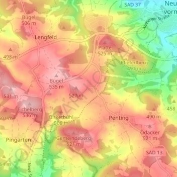
Nom : Carte topographique Wutzelskühn, altitude, relief.
Altitude moyenne : 474 m
Altitude minimum : 378 m
Altitude maximum : 538 m
Faire un don
Équipez-vous pour votre prochaine aventure :
En tant que Partenaire Amazon, ce site perçoit une commission sur les achats éligibles sans surcoût pour vous.