
Faire un don
Équipez-vous pour votre prochaine aventure :
En tant que Partenaire Amazon, ce site perçoit une commission sur les achats éligibles sans surcoût pour vous.
Carte topographique Thuvakudi
Cliquez sur la carte pour afficher l’altitude.
Faire un don
Équipez-vous pour votre prochaine aventure :
En tant que Partenaire Amazon, ce site perçoit une commission sur les achats éligibles sans surcoût pour vous.
Thuvakudi
Thuvakudi is located at 10°45′23″N 78°48′04″E / 10.756389°N 78.801111°E / 10.756389; 78.801111. The average elevation is 88 metres (289 ft). The topology of Thuvakudi is almost flat with a few isolated hillocks rising above the surface. The city spread over an area of 14.371 square kilometres (5.549 sq mi) is situated between Tiruchirapalli and Thanjavur. Red soil is the most common type of soil, which is conducive for dry crops like chillies, cotton and groundnut. Thuvakudi is hot and dry for at least eight months of the year. The hottest months are from March to July during which the city experiences frequent dust storms. During this period, the days are extremely warm and dry while evenings are rendered cooler due to the cold winds that blow from the south-east. Thuvakudi experiences a moderate climate from August to October, tempered by heavy rain and thundershowers, and cool and balmy climate from November to February. Fog and dew are rare and occur only during the winter season. It receives an average annual rainfall of around 850 mm (33 in)
Faire un don
Équipez-vous pour votre prochaine aventure :
En tant que Partenaire Amazon, ce site perçoit une commission sur les achats éligibles sans surcoût pour vous.
À propos de cette carte
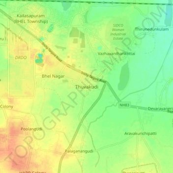
Nom : Carte topographique Thuvakudi, altitude, relief.
Altitude moyenne : 78 m
Altitude minimum : 58 m
Altitude maximum : 98 m
Faire un don
Équipez-vous pour votre prochaine aventure :
En tant que Partenaire Amazon, ce site perçoit une commission sur les achats éligibles sans surcoût pour vous.