
Carte topographique Richmond
Carte interactive
Cliquez sur la carte pour afficher l’altitude.
À propos de cette carte
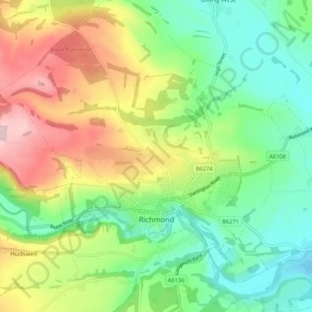
Nom : Carte topographique Richmond, altitude, relief.
Altitude moyenne : 166 m
Altitude minimum : 70 m
Altitude maximum : 321 m
Autres cartes topographiques
Cliquez sur une carte pour visualiser sa topographie, son altitude et son relief.
Marske
United Kingdom > England > North Yorkshire > Richmondshire
Marske, Richmondshire, North Yorkshire, England, United Kingdom
Altitude moyenne : 282 m
Dalton Gates
United Kingdom > England > North Yorkshire > Richmondshire > North Cowton
Dalton Gates, North Cowton, Richmondshire, North Yorkshire, England, DL7 0JU, United Kingdom
Altitude moyenne : 55 m