
Carte topographique Garstang
Carte interactive
Cliquez sur la carte pour afficher l’altitude.
À propos de cette carte
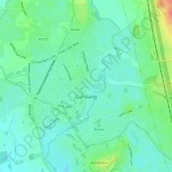
Nom : Carte topographique Garstang, altitude, relief.
Lieu : Garstang, Borough of Wyre, Lancashire, England, United Kingdom (53.89262 -2.79394 53.91382 -2.76443)
Altitude moyenne : 24 m
Altitude minimum : 10 m
Altitude maximum : 59 m
Autres cartes topographiques
Cliquez sur une carte pour visualiser sa topographie, son altitude et son relief.
Inskip
United Kingdom > England > Lancashire > Borough of Wyre
Inskip, Borough of Wyre, Lancashire, England, PR4 0SL, United Kingdom
Altitude moyenne : 14 m
Forton
United Kingdom > England > Lancashire > Borough of Wyre
Forton, Borough of Wyre, Lancashire, England, PR3 0BG, United Kingdom
Altitude moyenne : 30 m