
Carte topographique Manila
Carte interactive
Cliquez sur la carte pour afficher l’altitude.
À propos de cette carte
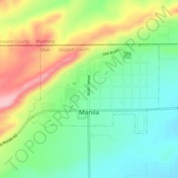
Nom : Carte topographique Manila, altitude, relief.
Lieu : Manila, Daggett County, Utah, 84046, United States (40.98478 -109.73517 40.99824 -109.70854)
Altitude moyenne : 1 964 m
Altitude minimum : 1 890 m
Altitude maximum : 2 085 m
Autres cartes topographiques
Cliquez sur une carte pour visualiser sa topographie, son altitude et son relief.
Linwood Bay
United States > Utah > Daggett County
Linwood Bay, Daggett County, Utah, United States
Altitude moyenne : 1 852 m
Red Lake
United States > Utah > Daggett County
Red Lake, Daggett County, Utah, United States
Altitude moyenne : 3 065 m