
Faire un don
Équipez-vous pour votre prochaine aventure :
En tant que Partenaire Amazon, ce site perçoit une commission sur les achats éligibles sans surcoût pour vous.
Carte topographique Cahas Mountain
Cliquez sur la carte pour afficher l’altitude.
Faire un don
Équipez-vous pour votre prochaine aventure :
En tant que Partenaire Amazon, ce site perçoit une commission sur les achats éligibles sans surcoût pour vous.
À propos de cette carte
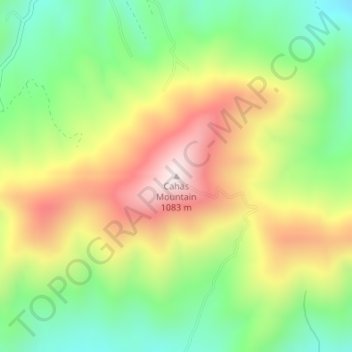
Nom : Carte topographique Cahas Mountain, altitude, relief.
Lieu : Cahas Mountain, Franklin County, Virginia, United States (37.11731 -80.01564 37.11741 -80.01554)
Altitude moyenne : 755 m
Altitude minimum : 511 m
Altitude maximum : 1 061 m
Faire un don
Équipez-vous pour votre prochaine aventure :
En tant que Partenaire Amazon, ce site perçoit une commission sur les achats éligibles sans surcoût pour vous.
Autres cartes topographiques
Cliquez sur une carte pour visualiser sa topographie, son altitude et son relief.
Faire un don
Équipez-vous pour votre prochaine aventure :
En tant que Partenaire Amazon, ce site perçoit une commission sur les achats éligibles sans surcoût pour vous.
Boones Mill
United States > Virginia > Franklin County
According to the United States Census Bureau, the town has a total area of 0.73 square miles (1.9 km2), all of it land. The town is in the valley of Maggodee Creek, a southeast-flowing tributary of the Blackwater River, part of the Roanoke River watershed. Murray Knob, elevation 2,286 feet (697 m), rises 2…
Altitude moyenne : 390 m
Faire un don
Équipez-vous pour votre prochaine aventure :
En tant que Partenaire Amazon, ce site perçoit une commission sur les achats éligibles sans surcoût pour vous.