Géolocaliser

Carte topographique Westwoodside

Cliquez sur la carte pour afficher l’altitude.

À propos de cette carte
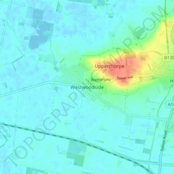
Nom : Carte topographique Westwoodside, altitude, relief.

Lieu : Westwoodside, Haxey, North Lincolnshire, England, DN9 2ED, United Kingdom (53.46722 -0.88940 53.50722 -0.84940)

Altitude moyenne : 7 m

Altitude minimum : -5 m

Altitude maximum : 42 m

Autres cartes topographiques

Cliquez sur une carte pour visualiser sa topographie, son altitude et son relief.

Kirmington

United Kingdom > England > North Lincolnshire

Altitude moyenne : 38 m

Wootton

United Kingdom > England > North Lincolnshire

Altitude moyenne : 45 m

Bottesford

United Kingdom > England > North Lincolnshire

Altitude moyenne : 23 m

Bonby

United Kingdom > England > North Lincolnshire

Altitude moyenne : 34 m

Broughton

United Kingdom > England > North Lincolnshire

Altitude moyenne : 24 m

Brigg

United Kingdom > England > North Lincolnshire

Altitude moyenne : 6 m

Winterton

United Kingdom > England > North Lincolnshire

Altitude moyenne : 19 m

Hibaldstow

United Kingdom > England > North Lincolnshire

Altitude moyenne : 19 m

Horkstow

United Kingdom > England > North Lincolnshire

Altitude moyenne : 37 m

Alkborough

United Kingdom > England > North Lincolnshire

Altitude moyenne : 18 m

Belton

United Kingdom > England > North Lincolnshire

Altitude moyenne : 4 m

Wroot

United Kingdom > England > North Lincolnshire

Altitude moyenne : 2 m

Appleby

United Kingdom > England > North Lincolnshire

Altitude moyenne : 19 m

Gunness

United Kingdom > England > North Lincolnshire

Altitude moyenne : 3 m

Worlaby

United Kingdom > England > North Lincolnshire

Altitude moyenne : 37 m

Haxey

United Kingdom > England > North Lincolnshire

The civil parish includes the town of Haxey and the village of Westwoodside, and the hamlets of Haxey Carr, High Burnham (the highest elevation of the Isle of Axholme), Low Burnham, East Lound, Graizelound and Upperthorpe which is conjoined to Westwoodside.

Altitude moyenne : 7 m

Broughton

United Kingdom > England > North Lincolnshire

Altitude moyenne : 26 m

Brigg

United Kingdom > England > North Lincolnshire

Altitude moyenne : 6 m

Alkborough

United Kingdom > England > North Lincolnshire

Altitude moyenne : 18 m

Epworth

United Kingdom > England > North Lincolnshire

Altitude moyenne : 6 m

Winterton

United Kingdom > England > North Lincolnshire

Altitude moyenne : 19 m

Winterton

United Kingdom > England > North Lincolnshire

Altitude moyenne : 19 m

Équipez-vous pour votre prochaine aventure :

🍴Couverts de Voyage - Set de couverts compacts et durables en titane ou inox.
🌂Parapluie de Marche - Alternative à la veste pour rester au sec sans transpirer.
📻Radio d'Urgence - Réception météo et info sans piles, idéale pour les zones isolées.
🎒Poche à Eau - Réservoir d'eau avec tuyau pour s'hydrater sans s'arrêter.
🐕Harnais Chien Outdoor - Emmenez votre compagnon sur les sentiers luxembourgeois.

En tant que Partenaire Amazon, ce site perçoit une commission sur les achats éligibles sans surcoût pour vous.