Géolocaliser

Carte topographique Ballyconnell

Cliquez sur la carte pour afficher l’altitude.

À propos de cette carte

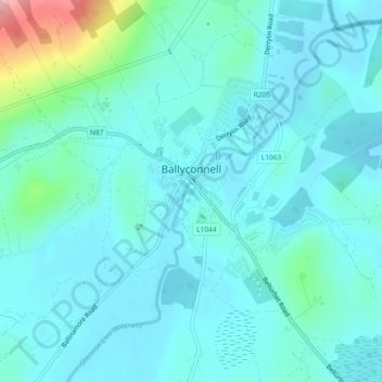
Nom : Carte topographique Ballyconnell, altitude, relief.

Lieu : Ballyconnell, Ballyconnell ED, Cavan-Belturbet Municipal District, County Cavan, Ulster, H14 EC99, Ireland (54.10645 -7.58993 54.12373 -7.56597)

Altitude moyenne : 68 m

Altitude minimum : 45 m

Altitude maximum : 194 m

Autres cartes topographiques

Cliquez sur une carte pour visualiser sa topographie, son altitude et son relief.

Lettermore

Ireland > County Cavan

Altitude moyenne : 90 m

Cornaseer

Ireland > County Cavan

Altitude moyenne : 113 m

Ballinagh

Ireland > County Cavan > Bellananagh

Altitude moyenne : 94 m

Blacklion

Ireland > County Cavan

Altitude moyenne : 92 m

Stradone

Ireland > County Cavan

Altitude moyenne : 117 m

Bawnboy

Ireland > County Cavan

Altitude moyenne : 63 m

Corlismore

Ireland > County Cavan

Altitude moyenne : 73 m

Laragh

Ireland > County Cavan

Altitude moyenne : 166 m

Coragh Lough

Ireland > County Cavan

Altitude moyenne : 98 m

Ardamagh

Ireland > County Cavan

Altitude moyenne : 84 m

Drumard

Ireland > County Cavan

Altitude moyenne : 55 m

Lettermore

Ireland > County Cavan

Altitude moyenne : 90 m

Swanlinbar

Ireland > County Cavan

Altitude moyenne : 97 m

Ballyhaise

Ireland > County Cavan

Ballyhaise Bridge was built around 1710 by Colonel Brockhill Newburgh. It is made from roughly coursed limestone elevations which have elliptical arches having cut-stone arch rings. The bridge was positioned on a central axis with Ballyhaise House, which acts as a reminder of the formally laid out demesne. Its…

Altitude moyenne : 82 m

Ballinagh

Ireland > County Cavan

Altitude moyenne : 82 m

Shannon Pot

Ireland > County Cavan

Altitude moyenne : 134 m

Kilnaleck

Ireland > County Cavan

Altitude moyenne : 114 m

Dowra

Ireland > County Cavan > Dowra

Altitude moyenne : 67 m

Crossdoney

Ireland > County Cavan

Altitude moyenne : 67 m

Mount Nugent

Ireland > County Cavan

Altitude moyenne : 74 m

Cornafean

Ireland > County Cavan

Altitude moyenne : 82 m

Bailieborough

Ireland > County Cavan > Bailieborough

Altitude moyenne : 169 m

Cornamucklagh

Ireland > County Cavan > Cornamucklagh

Altitude moyenne : 61 m

Équipez-vous pour votre prochaine aventure :

🔪Couteau de Poche - L'outil indispensable pour toutes les situations en extérieur.
🧤Gants de Randonnée - Gants légers et tactiles pour manipuler vos cartes par temps froid.
🥾Guêtres de randonnée - Protection contre boue et neige
🩹Trousse de premiers secours - Kits essentiels pour sécurité en randonnée
🧢Casquettes sport - Protection solaire respirante

En tant que Partenaire Amazon, ce site perçoit une commission sur les achats éligibles sans surcoût pour vous.