
Carte topographique Smallwood
Cliquez sur la carte pour afficher l’altitude.
À propos de cette carte
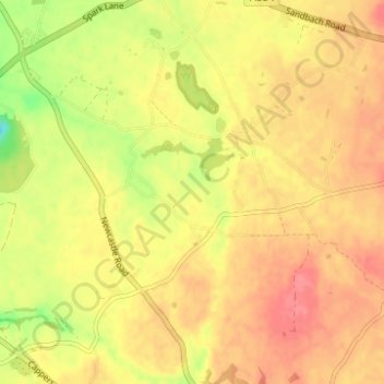
Nom : Carte topographique Smallwood, altitude, relief.
Lieu : Smallwood, Cheshire East, England, United Kingdom (53.12462 -2.31666 53.16174 -2.26471)
Altitude moyenne : 86 m
Altitude minimum : 45 m
Altitude maximum : 109 m
Autres cartes topographiques
Cliquez sur une carte pour visualiser sa topographie, son altitude et son relief.
Bickerton Hill
United Kingdom > England > Cheshire East > Bickerton
Bickerton Hill refers to two low red sandstone hills that form the southern end of the Mid Cheshire Ridge in Cheshire, north-west England. The high point, Raw Head, lies on the northerly hill and has an elevation of 227 metres. Parts of the southerly hill are also known as Larkton Hill.
Altitude moyenne : 134 m