
Faire un don
Équipez-vous pour votre prochaine aventure :
En tant que Partenaire Amazon, ce site perçoit une commission sur les achats éligibles sans surcoût pour vous.
Carte topographique Monument
Cliquez sur la carte pour afficher l’altitude.
Faire un don
Équipez-vous pour votre prochaine aventure :
En tant que Partenaire Amazon, ce site perçoit une commission sur les achats éligibles sans surcoût pour vous.
Monument
Monument experiences a hemiboreal continental climate (Köppen Dfb) with warm, relatively rainy summers and cold, snowy winters. The semi-arid climate keeps the dew point very low in Monument year-round which causes the air to feel quite dry. Monument is part of the Front Range urban corridor and lies on the southern slope of Monument Hill. The town is situated near the western terminus of the Palmer Divide, a low-grade ridge that extends eastward from the Front Range and has a significant impact on Monument's climate. With Monument Hill reaching 7,352 feet above sea level, Monument is one of the highest communities in the Front Range urban corridor. The combination of high elevation, uniquely situated geography, semi-arid climate, and freezing cold winter months, the town of Monument receives considerably more snow each year than its neighboring cities. Colorado Springs (20 miles to the South) receives an average of 33 inches of snow per year and Denver (53 miles to the North) receives an average of 56 inches of snow per year, whereas the town of Monument receives an average of 110 inches of snow per year.
Faire un don
Équipez-vous pour votre prochaine aventure :
En tant que Partenaire Amazon, ce site perçoit une commission sur les achats éligibles sans surcoût pour vous.
À propos de cette carte
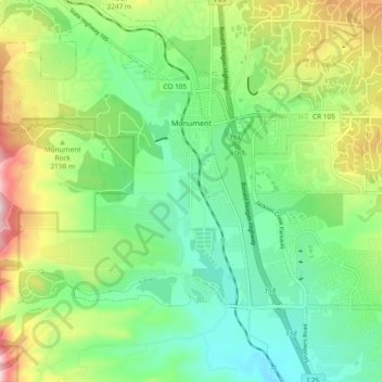
Nom : Carte topographique Monument, altitude, relief.
Lieu : Monument, El Paso County, Colorado, United States (39.04220 -104.88472 39.11504 -104.79116)
Altitude moyenne : 2 160 m
Altitude minimum : 2 035 m
Altitude maximum : 2 409 m
Faire un don
Équipez-vous pour votre prochaine aventure :
En tant que Partenaire Amazon, ce site perçoit une commission sur les achats éligibles sans surcoût pour vous.
Autres cartes topographiques
Cliquez sur une carte pour visualiser sa topographie, son altitude et son relief.
Colorado Springs
United States > Colorado > El Paso County
At 6,035 feet (1,839 m) the city stands over 1 mile (1.6 km) above sea level. Colorado Springs is near the base of Pikes Peak, which rises 14,115 feet (4,302.31 m) above sea level on the eastern edge of the Southern Rocky Mountains. The city is the largest city north of Mexico above 6000 feet in elevation.
Altitude moyenne : 2 252 m
Colorado Springs
United States > Colorado > El Paso County
Colorado Springs boasts a diverse and striking topography characterized by its high elevation and mountainous terrain. Nestled at approximately 6,035 feet (1,839 meters) above sea level, the city is flanked by the majestic Pikes Peak, which rises dramatically to 14,115 feet (4,302 meters), forming part of the…
Altitude moyenne : 2 252 m
Pikes Peak
United States > Colorado > El Paso County
Pikes Peak or America's Mountain is an ultra-prominent fourteener of the Front Range of the Rocky Mountains of North America. Pikes Peak's summit has an elevation of 14,115 ft (4,302 m) above sea level. Pikes Peak is in Pike National Forest, Colorado, with the base located in the town of Manitou Springs, 10…
Altitude moyenne : 3 902 m
Palmer Lake
United States > Colorado > El Paso County
The town marks the top of the Palmer Divide, a ridge running from Palmer Lake eastward which separates the Arkansas River drainage to the south from the Platte River drainage to the north. The highest point of the divide is about 7,700 feet (2,300 m) above sea level at Vollmer Hill located in the Black Forest.…
Altitude moyenne : 2 302 m
Faire un don
Équipez-vous pour votre prochaine aventure :
En tant que Partenaire Amazon, ce site perçoit une commission sur les achats éligibles sans surcoût pour vous.
Faire un don
Équipez-vous pour votre prochaine aventure :
En tant que Partenaire Amazon, ce site perçoit une commission sur les achats éligibles sans surcoût pour vous.
Faire un don
Équipez-vous pour votre prochaine aventure :
En tant que Partenaire Amazon, ce site perçoit une commission sur les achats éligibles sans surcoût pour vous.
Faire un don
Équipez-vous pour votre prochaine aventure :
En tant que Partenaire Amazon, ce site perçoit une commission sur les achats éligibles sans surcoût pour vous.
Rampart Reservoir
United States > Colorado > El Paso County
The reservoir supplies water to the Tesla Hydroelectric Facility. Colorado Springs Utilities built and operates this hydroelectric power plant, which opened in 1997. Water from the reservoir flows down a shaft called the Stanley Tunnel and then into the turbines in a powerhouse located in the foothills west of…
Altitude moyenne : 2 765 m
Garden of the Gods Park
United States > Colorado > El Paso County > Colorado Springs
Altitude moyenne : 1 982 m
Faire un don
Équipez-vous pour votre prochaine aventure :
En tant que Partenaire Amazon, ce site perçoit une commission sur les achats éligibles sans surcoût pour vous.
Colorado Springs
United States > Colorado > El Paso County
Snowfall is usually moderate and remains on the ground briefly because of direct sun, with the city receiving 38 inches (97 cm) per season, although the mountains to the west often receive in excess of triple that amount; March is the snowiest month in the region, both by total accumulation and number of days…
Altitude moyenne : 2 229 m
Pikes Peak
United States > Colorado > El Paso County
The uppermost portion of Pikes Peak, above 14,000 feet (4,300 m) elevation, was declared a National Historic Landmark in 1961.
Altitude moyenne : 3 902 m
Palmer Lake
United States > Colorado > El Paso County
The town marks the top of the Palmer Divide, a ridge running from Palmer Lake eastward which separates the Arkansas River drainage to the south from the Platte River drainage to the north. The highest point of the divide is about 7,700 feet (2,300 m) above sea level at Vollmer Hill located in the Black Forest.…
Altitude moyenne : 2 302 m
Faire un don
Équipez-vous pour votre prochaine aventure :
En tant que Partenaire Amazon, ce site perçoit une commission sur les achats éligibles sans surcoût pour vous.
Colorado Springs
United States > Colorado > El Paso County
At 6,035 feet (1,839 m) the city stands over 1 mile (1.6 km) above sea level. Colorado Springs is near the base of Pikes Peak, which rises 14,115 feet (4,302.31 m) above sea level on the eastern edge of the Southern Rocky Mountains. The city is the largest city north of Mexico above 6000 feet in elevation.
Altitude moyenne : 2 252 m
Pikes Peak
United States > Colorado > El Paso County
Soils on Pikes Peak above the timberline (approximately 12,000 ft or 3,700 m) are classified as Cirque land. Forests at lower altitudes mostly lie over the brown stony, sandy, loams of the Catamount loam or Ivywild loam series.
Altitude moyenne : 3 902 m
Faire un don
Équipez-vous pour votre prochaine aventure :
En tant que Partenaire Amazon, ce site perçoit une commission sur les achats éligibles sans surcoût pour vous.
Palmer Lake
United States > Colorado > El Paso County
The town marks the top of the Palmer Divide, a ridge running from Palmer Lake eastward which separates the Arkansas River drainage to the south from the Platte River drainage to the north. The highest point of the divide is about 7,700 feet (2,300 m) above sea level at Vollmer Hill located in the Black Forest.…
Altitude moyenne : 2 302 m
Colorado Springs
United States > Colorado > El Paso County
At 6,035 feet (1,839 m) the city stands over 1 mile (1.6 km) above sea level. Colorado Springs is near the base of Pikes Peak, which rises 14,115 feet (4,302.31 m) above sea level on the eastern edge of the Southern Rocky Mountains. The city is the largest city north of Mexico above 6000 feet in elevation.
Altitude moyenne : 2 252 m
Faire un don
Équipez-vous pour votre prochaine aventure :
En tant que Partenaire Amazon, ce site perçoit une commission sur les achats éligibles sans surcoût pour vous.
Faire un don
Équipez-vous pour votre prochaine aventure :
En tant que Partenaire Amazon, ce site perçoit une commission sur les achats éligibles sans surcoût pour vous.
Ben Lomand Mountain
United States > Colorado > El Paso County > Palmer Lake
Altitude moyenne : 2 220 m
Faire un don
Équipez-vous pour votre prochaine aventure :
En tant que Partenaire Amazon, ce site perçoit une commission sur les achats éligibles sans surcoût pour vous.
Ben Lomand Mountain
United States > Colorado > El Paso County > Palmer Lake
Altitude moyenne : 2 220 m
Garden of the Gods Park
United States > Colorado > El Paso County > Colorado Springs
Altitude moyenne : 1 982 m
Faire un don
Équipez-vous pour votre prochaine aventure :
En tant que Partenaire Amazon, ce site perçoit une commission sur les achats éligibles sans surcoût pour vous.
Colorado Springs
United States > Colorado > El Paso County
At 6,035 feet (1,839 m) the city stands over 1 mile (1.6 km) above sea level. Colorado Springs is near the base of Pikes Peak, which rises 14,115 feet (4,302.31 m) above sea level on the eastern edge of the Southern Rocky Mountains. The city is the largest city north of Mexico above 6000 feet in elevation.
Altitude moyenne : 2 252 m