
Carte topographique Pagan Island
Carte interactive
Cliquez sur la carte pour afficher l’altitude.
À propos de cette carte
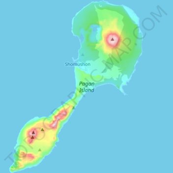
Nom : Carte topographique Pagan Island, altitude, relief.
Altitude moyenne : 35 m
Altitude minimum : -1 m
Altitude maximum : 550 m
Autres cartes topographiques
Cliquez sur une carte pour visualiser sa topographie, son altitude et son relief.
Northern Islands Municipality
United States > Northern Mariana Islands > Northern Islands Municipality
Northern Islands Municipality, Northern Mariana Islands, United States
Altitude moyenne : 8 m