
Carte topographique Corbion
Carte interactive
Cliquez sur la carte pour afficher l’altitude.
À propos de cette carte
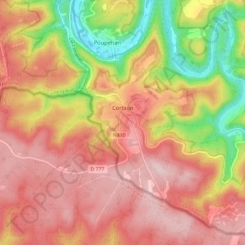
Nom : Carte topographique Corbion, altitude, relief.
Altitude moyenne : 344 m
Altitude minimum : 190 m
Altitude maximum : 443 m
Autres cartes topographiques
Cliquez sur une carte pour visualiser sa topographie, son altitude et son relief.
Noirefontaine
België > Luxemburg > Neufchâteau > Bouillon > Noirefontaine
Noirefontaine, Bouillon, Neufchâteau, Luxemburg, Wallonië, 6831, België
Altitude moyenne : 331 m
Dohan
België > Luxemburg > Neufchâteau > Bouillon
Dohan, Bouillon, Neufchâteau, Luxemburg, Wallonië, België
Altitude moyenne : 284 m
Rochehaut
België > Luxemburg > Neufchâteau > Bouillon
Rochehaut, Bouillon, Neufchâteau, Luxemburg, Wallonië, België
Altitude moyenne : 298 m
Poupehan
België > Luxemburg > Neufchâteau > Bouillon
Poupehan, Bouillon, Neufchâteau, Luxemburg, Wallonië, België
Altitude moyenne : 270 m