
Carte topographique Alvor
Carte interactive
Cliquez sur la carte pour afficher l’altitude.
Alvor
The Prince Regent ordered, in the name of Manuel of Portugal, the elevation of Alvor to vila (town) on 28 February 1495, which was confirmed in a secondary diploma on 28 December 1498.
À propos de cette carte
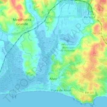
Nom : Carte topographique Alvor, altitude, relief.
Lieu : Alvor, Portimão, Faro, Portugal (37.11421 -8.62157 37.17064 -8.56067)
Altitude moyenne : 15 m
Altitude minimum : -3 m
Altitude maximum : 62 m
Autres cartes topographiques
Cliquez sur une carte pour visualiser sa topographie, son altitude et son relief.