
Faire un don
Équipez-vous pour votre prochaine aventure :
En tant que Partenaire Amazon, ce site perçoit une commission sur les achats éligibles sans surcoût pour vous.
Carte topographique Engelburg
Cliquez sur la carte pour afficher l’altitude.
Faire un don
Équipez-vous pour votre prochaine aventure :
En tant que Partenaire Amazon, ce site perçoit une commission sur les achats éligibles sans surcoût pour vous.
À propos de cette carte
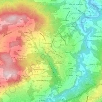
Nom : Carte topographique Engelburg, altitude, relief.
Altitude moyenne : 700 m
Altitude minimum : 535 m
Altitude maximum : 913 m
Faire un don
Équipez-vous pour votre prochaine aventure :
En tant que Partenaire Amazon, ce site perçoit une commission sur les achats éligibles sans surcoût pour vous.
Autres cartes topographiques
Cliquez sur une carte pour visualiser sa topographie, son altitude et son relief.
St. Gallen
Switzerland > St. Gallen > Wahlkreis St. Gallen
St. Gallen is notable for reporting the highest maximum radioactivity measurements of any Swiss city, as published in the 2009 yearly report by the Federal Office of Public Health. While the daily average level of gamma-ray radioactivity in the city is unremarkable at 105 nSv/h, the maximum can reach 195…
Altitude moyenne : 740 m
St. Gallen
Switzerland > St. Gallen > Wahlkreis St. Gallen
St. Gallen is notable for reporting the highest maximum radioactivity measurements of any Swiss city, as published in the 2009 yearly report by the Federal Office of Public Health. While the daily average level of gamma-ray radioactivity in the city is unremarkable at 105 nSv/h, the maximum can reach 195…
Altitude moyenne : 741 m
St. Gallen
Switzerland > St. Gallen > Wahlkreis St. Gallen
St. Gallen is notable for reporting the highest maximum radioactivity measurements of any Swiss city, as published in the 2009 yearly report by the Federal Office of Public Health. While the daily average level of gamma-ray radioactivity in the city is unremarkable at 105 nSv/h, the maximum can reach 195…
Altitude moyenne : 740 m