
Carte topographique Southern District
Carte interactive
Cliquez sur la carte pour afficher l’altitude.
À propos de cette carte
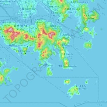
Nom : Carte topographique Southern District, altitude, relief.
Lieu : Southern District, Hong Kong Island, Hong Kong, China (22.19265 114.11011 22.27561 114.30905)
Altitude moyenne : 36 m
Altitude minimum : -6 m
Altitude maximum : 532 m
Autres cartes topographiques
Cliquez sur une carte pour visualiser sa topographie, son altitude et son relief.
Mount Cameron
China > Hong Kong > Hong Kong Island
Mount Cameron, Hong Kong Island, Hong Kong, China
Altitude moyenne : 153 m
Mount Davis
China > Hong Kong > Hong Kong Island
Mount Davis, Hong Kong Island, Hong Kong, 000000, China
Altitude moyenne : 71 m
Hong Kong Island
China > Hong Kong > Hong Kong Island
Hong Kong Island, Eastern District, Hong Kong, China
Altitude moyenne : 84 m