Géolocaliser

Carte topographique Loch Einich

Cliquez sur la carte pour afficher l’altitude.

À propos de cette carte

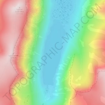
Nom : Carte topographique Loch Einich, altitude, relief.

Lieu : Loch Einich, Highland, Scotland, United Kingdom (57.06027 -3.79722 57.07739 -3.78600)

Altitude moyenne : 767 m

Altitude minimum : 492 m

Altitude maximum : 1 108 m

Autres cartes topographiques

Cliquez sur une carte pour visualiser sa topographie, son altitude et son relief.

Ben Nevis

United Kingdom > Scotland > Highland

Ben Nevis has a highland (alpine) maritime (oceanic) polar climate (ET climate in the Köppen classification). Ben Nevis's elevation, maritime location and topography frequently lead to cool and cloudy weather conditions, which can pose a danger to ill-equipped walkers. According to the observations carried…

Altitude moyenne : 912 m

Aviemore

United Kingdom > Scotland > Highland

Altitude moyenne : 331 m

Fort William

United Kingdom > Scotland > Highland

Fort William has an oceanic climate (Cfb) with moderate, but generally cool, temperatures and abundant precipitation. In the towns immediate vicinity, there are significant variations in elevation, which leads to some uninhabited areas near the town having a subpolar oceanic climate (Cfc), or, at the absolute…

Altitude moyenne : 122 m

Glencoe

United Kingdom > Scotland > Highland

Altitude moyenne : 114 m

Arisaig

United Kingdom > Scotland > Highland

Altitude moyenne : 54 m

Suilven

United Kingdom > Scotland > Highland

Altitude moyenne : 293 m

Achnacarry

United Kingdom > Scotland > Highland

Altitude moyenne : 183 m

Sgùrr a' Mhaoraich

United Kingdom > Scotland > Highland

Altitude moyenne : 662 m

Loch Coruisk

United Kingdom > Scotland > Highland

Altitude moyenne : 176 m

Inverness

United Kingdom > Scotland > Highland

Altitude moyenne : 163 m

Kingussie

United Kingdom > Scotland > Highland

Altitude moyenne : 338 m

Skye

United Kingdom > Scotland > Highland

Beyond Loch Snizort to the west of Trotternish is the Waternish peninsula, which ends in Ardmore Point's double rock arch. Duirinish peninsula is separated from Waternish by Loch Dunvegan, which contains the island of Isay. It is ringed by sea cliffs that reach 296 metres (971 feet) on the west at Waterstein…

Altitude moyenne : 63 m

Dunbeath

United Kingdom > Scotland > Highland

Altitude moyenne : 59 m

Creag na h-Iolaire

United Kingdom > Scotland > Highland

Altitude moyenne : 454 m

Maryburgh

United Kingdom > Scotland > Highland

Altitude moyenne : 56 m

Kintradwell

United Kingdom > Scotland > Highland

Altitude moyenne : 78 m

Aonach Beag

United Kingdom > Scotland > Highland

Aonach Beag is linked to its close neighbour to the north, Aonach Mòr, by a high saddle or bealach. The name Aonach Beag (small ridge) might imply that this mountain is smaller than Aonach Mòr (big ridge). However, Aonach Beag is higher; the names refer to the relative bulk of the two mountains rather than…

Altitude moyenne : 873 m

Carn Dearg

United Kingdom > Scotland > Highland

Altitude moyenne : 711 m

Càrn Eige

United Kingdom > Scotland > Highland

Carn Eighe (Scottish Gaelic: Càrn Èite) is a mountain in the Northwest Highlands of Scotland. Rising to 1,183 metres (3,881 ft) above sea level, it is the highest mountain in Scotland north of the Great Glen, the twelfth-highest in the British Isles, and, in terms of relative height (topographic prominence),…

Altitude moyenne : 867 m

Mam Sodhail

United Kingdom > Scotland > Highland

Altitude moyenne : 876 m

Bidean nam Bian

United Kingdom > Scotland > Highland

Altitude moyenne : 733 m

Beinn Alligin

United Kingdom > Scotland > Highland

Altitude moyenne : 566 m

Ben Hope

United Kingdom > Scotland > Highland

Altitude moyenne : 490 m

Ben Klibreck

United Kingdom > Scotland > Highland

Ben Klibreck (Scottish Gaelic: Beinn Chlìbric) is a Scottish mountain located in central Sutherland. It is an isolated mountain, rising above a large area of moorland. The highest point, Meall nan Con (the mound of the dogs), rises to 962 metres (3,156 ft) elevation and is therefore the second most northerly…

Altitude moyenne : 551 m

Canisp

United Kingdom > Scotland > Highland

Canisp is an isolated mountain that stands in the Glencanisp Forest, a large rock and water wilderness. It has a topographic prominence of 691 metres (2,267 ft). Canisp has little vegetation, even on its lower slopes large areas of Gneiss (one of the oldest rocks in the world) are visible on the surface.

Altitude moyenne : 467 m

Foinaven

United Kingdom > Scotland > Highland

Altitude moyenne : 552 m

Ladhar Bheinn

United Kingdom > Scotland > Highland

Altitude moyenne : 574 m

Sgùrr na Cìche

United Kingdom > Scotland > Highland

Altitude moyenne : 558 m

Sgùrr Mòr

United Kingdom > Scotland > Highland

Altitude moyenne : 565 m

Spidean Mialach

United Kingdom > Scotland > Highland

Altitude moyenne : 622 m

Gairich

United Kingdom > Scotland > Highland

Altitude moyenne : 472 m

Sgùrr na Lapaich

United Kingdom > Scotland > Highland

With a topographic prominence of 839 metres, Sgurr na Lapaich is the highest point for some considerable distance and is a fine viewpoint. The mountain is particularly well seen from the east; it is a prominent landmark as far away as the Moray Firth, some thirty miles away, from where locals use it as a guide…

Altitude moyenne : 796 m

Sgurr nan Conbhairean

United Kingdom > Scotland > Highland

Altitude moyenne : 774 m

Mullach Fraoch-choire

United Kingdom > Scotland > Highland

Altitude moyenne : 741 m

Sgùrr Fhuaran

United Kingdom > Scotland > Highland

The mountain reaches a height of 1,067 metres (3,501 ft) and qualifies as a Munro and a Marilyn; it is the highest point for a significant distance, having a sizeable topographic prominence of 663 metres (2,175 ft) and giving extensive views from its summit.

Altitude moyenne : 604 m

Sgùrr na Càrnach

United Kingdom > Scotland > Highland

From 1891 to 1997 Sgùrr na Càrnach was ranked as just a "Top" of the nearby Munro of Sgùrr Fhuraran and was not given separate Munro status, however in the 1997 revision of the tables by the Scottish Mountaineering Club, the mountain was elevated to the Munro category as it was decided that with 134 metres…

Altitude moyenne : 589 m

Sgùrr Mhic Choinnich

United Kingdom > Scotland > Highland

Altitude moyenne : 563 m

Sgùrr Dearg

United Kingdom > Scotland > Highland

Altitude moyenne : 560 m

Blà Bheinn

United Kingdom > Scotland > Highland

Altitude moyenne : 410 m

Marsco

United Kingdom > Scotland > Highland

Altitude moyenne : 248 m

Sgùrr Mhàiri

United Kingdom > Scotland > Highland

Altitude moyenne : 298 m

Askival

United Kingdom > Scotland > Highland

Altitude moyenne : 401 m

Hallival

United Kingdom > Scotland > Highland

Altitude moyenne : 396 m

Ainshval

United Kingdom > Scotland > Highland

Altitude moyenne : 427 m

Roineval

United Kingdom > Scotland > Highland

Altitude moyenne : 290 m

Ben Hee

United Kingdom > Scotland > Highland

Altitude moyenne : 612 m

Ben Starav

United Kingdom > Scotland > Highland

Altitude moyenne : 617 m

Beinn Mheadhonach

United Kingdom > Scotland > Highland

Altitude moyenne : 336 m

Beinn Fhionnlaidh

United Kingdom > Scotland > Highland

Altitude moyenne : 549 m

Beinn a' Bheithir

United Kingdom > Scotland > Highland

Altitude moyenne : 552 m

Sgùrr Dhòmhnuill

United Kingdom > Scotland > Highland

Altitude moyenne : 497 m

Sgúrr nan Eugallt

United Kingdom > Scotland > Highland

An old stalkers' path from the ruined cottage should guide the climber to a point just below a ridge at about 650 metres. The path was well built in its time but some sections have become wet and slippery. On gaining the ridge, turn left and follow the ridge to the 894 m triangulation point. The ridge becomes…

Altitude moyenne : 539 m

Sgùrr na Sgine

United Kingdom > Scotland > Highland

Altitude moyenne : 605 m

The Saddle

United Kingdom > Scotland > Highland

Altitude moyenne : 660 m

Sgùrr nan Saighead

United Kingdom > Scotland > Highland

Altitude moyenne : 533 m

Aonach air Chrith

United Kingdom > Scotland > Highland

Altitude moyenne : 618 m

Maol Chinn-dearg

United Kingdom > Scotland > Highland

Altitude moyenne : 587 m

Creag a' Mhaim

United Kingdom > Scotland > Highland

Altitude moyenne : 562 m

Druim Shionnach

United Kingdom > Scotland > Highland

Altitude moyenne : 666 m

Sgurr an Lochain

United Kingdom > Scotland > Highland

Altitude moyenne : 621 m

Gleouraich

United Kingdom > Scotland > Highland

Altitude moyenne : 623 m

Sgùrr nan Coireachan

United Kingdom > Scotland > Highland

Altitude moyenne : 561 m

Sgùrr Thuilm

United Kingdom > Scotland > Highland

Altitude moyenne : 545 m

Am Basteir

United Kingdom > Scotland > Highland

Altitude moyenne : 553 m

Sgùrr a' Mhadaidh

United Kingdom > Scotland > Highland

Altitude moyenne : 539 m

Sgùrr a' Ghreadaidh

United Kingdom > Scotland > Highland

Altitude moyenne : 557 m

Sgùrr Dubh Mòr

United Kingdom > Scotland > Highland

Altitude moyenne : 541 m

Sgùrr nan Eag

United Kingdom > Scotland > Highland

Altitude moyenne : 528 m

Monadhliath Mountains

United Kingdom > Scotland > Highland

Altitude moyenne : 454 m

Fisherfield Forest

United Kingdom > Scotland > Highland

Altitude moyenne : 153 m

Black Mount

United Kingdom > Scotland > Highland

Altitude moyenne : 229 m

River Lochy

United Kingdom > Scotland > Highland > Fort William

Altitude moyenne : 155 m

River Findhorn

United Kingdom > Scotland > Highland

Altitude moyenne : 278 m

Toigal

United Kingdom > Scotland > Highland > Morar

Altitude moyenne : 28 m

Loch Eil

United Kingdom > Scotland > Highland > Blaich

Altitude moyenne : 226 m

Loch Sionascaig

United Kingdom > Scotland > Highland

Altitude moyenne : 97 m

Loch Lurgainn

United Kingdom > Scotland > Highland

Altitude moyenne : 227 m

Loch Stac

United Kingdom > Scotland > Highland > Achfary

Altitude moyenne : 132 m

Loch Merkland

United Kingdom > Scotland > Highland > West Merkland

Altitude moyenne : 272 m

Loch Gairloch

United Kingdom > Scotland > Highland > Badachro

Altitude moyenne : 30 m

Loch Coulin

United Kingdom > Scotland > Highland

Altitude moyenne : 214 m

Loch Snizort

United Kingdom > Scotland > Highland > Geary

Altitude moyenne : 33 m

Loch Dunvegan

United Kingdom > Scotland > Highland > Stein

Altitude moyenne : 61 m

Sound of Raasay

United Kingdom > Scotland > Highland > Oskaig

Altitude moyenne : 87 m

Dornoch Firth

United Kingdom > Scotland > Highland > Ardgay

Altitude moyenne : 61 m

Uig

United Kingdom > Scotland > Highland

Altitude moyenne : 103 m

Duisdalebeg

United Kingdom > Scotland > Highland > Camuscross

Altitude moyenne : 51 m

Muck

United Kingdom > Scotland > Highland > Port Mòr

Altitude moyenne : 10 m

Coire Lagan

United Kingdom > Scotland > Highland

Altitude moyenne : 510 m

the Black Isle

United Kingdom > Scotland > Highland

Altitude moyenne : 82 m

Raddery

United Kingdom > Scotland > Highland > Fortrose

Altitude moyenne : 129 m

Corpach

United Kingdom > Scotland > Highland

Altitude moyenne : 83 m

Ardnarff

United Kingdom > Scotland > Highland

Altitude moyenne : 156 m

Knoydart

United Kingdom > Scotland > Highland > Inverie

Altitude moyenne : 216 m

Langdale

United Kingdom > Scotland > Highland

Altitude moyenne : 115 m

Équipez-vous pour votre prochaine aventure :

🔋Batterie Solaire Portable - Réserve d'énergie pour vos appareils électroniques en pleine nature.
🧷Kit de Réparation Tissu - Réparez un accroc sur votre veste ou tente instantanément.
🕶️Lunettes de soleil sport - Lunettes filtrantes pour activités en plein air
🚶Chaussures de trail - Chaussures légères pour sentiers
🌂Parapluie de Marche - Alternative à la veste pour rester au sec sans transpirer.

En tant que Partenaire Amazon, ce site perçoit une commission sur les achats éligibles sans surcoût pour vous.