
Faire un don
Équipez-vous pour votre prochaine aventure :
En tant que Partenaire Amazon, ce site perçoit une commission sur les achats éligibles sans surcoût pour vous.
Carte topographique Ramos Arizpe
Cliquez sur la carte pour afficher l’altitude.
Faire un don
Équipez-vous pour votre prochaine aventure :
En tant que Partenaire Amazon, ce site perçoit une commission sur les achats éligibles sans surcoût pour vous.
Ramos Arizpe
Ramos Arizpe has a desert climate (Köppen climate classification BWh Owing to its altitude of 1,400 to 1,500 m (4,600 to 4,900 ft) above sea level, temperatures are milder than other desert cities at lower elevations. Winters are mild with warm temperatures during the day and cold nights. The January average temperature is 11.9 °C (53.4 °F). On average, temperatures drop below freezing on 18 days per year, which can occur in the months November to April. Occasionally, it can receive snowfall. Precipitation is low during the winter months and many days are clear and sunny, averaging 20-22 clear days from December to March.
Faire un don
Équipez-vous pour votre prochaine aventure :
En tant que Partenaire Amazon, ce site perçoit une commission sur les achats éligibles sans surcoût pour vous.
À propos de cette carte
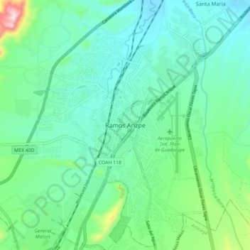
Nom : Carte topographique Ramos Arizpe, altitude, relief.
Lieu : Ramos Arizpe, Coahuila, 25900, Mexico (25.50079 -100.98667 25.58079 -100.90667)
Altitude moyenne : 1 426 m
Altitude minimum : 1 337 m
Altitude maximum : 1 756 m
Faire un don
Équipez-vous pour votre prochaine aventure :
En tant que Partenaire Amazon, ce site perçoit une commission sur les achats éligibles sans surcoût pour vous.