
Faire un don
Équipez-vous pour votre prochaine aventure :
En tant que Partenaire Amazon, ce site perçoit une commission sur les achats éligibles sans surcoût pour vous.
Carte topographique Nkareta ward
Cliquez sur la carte pour afficher l’altitude.
Faire un don
Équipez-vous pour votre prochaine aventure :
En tant que Partenaire Amazon, ce site perçoit une commission sur les achats éligibles sans surcoût pour vous.
À propos de cette carte
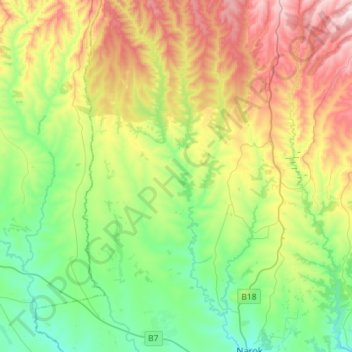
Nom : Carte topographique Nkareta ward, altitude, relief.
Lieu : Nkareta ward, Narok North, Narok, Rift Valley, Kenya (-1.08921 35.73582 -0.80357 35.94573)
Altitude moyenne : 2 118 m
Altitude minimum : 1 851 m
Altitude maximum : 2 608 m
Faire un don
Équipez-vous pour votre prochaine aventure :
En tant que Partenaire Amazon, ce site perçoit une commission sur les achats éligibles sans surcoût pour vous.
Autres cartes topographiques
Cliquez sur une carte pour visualiser sa topographie, son altitude et son relief.
Narok
Kenya > Narok > Narok North > Narok Town ward
Narok (sometimes referred to as NauwongoTown) is a town west of Nairobi that supports Kenya's economy in south-west of the country, along the Great Rift Valley. Narok is the county capital of the Narok County and stands as the major centre of commerce in the county. Narok has a population of around 117, 607…
Altitude moyenne : 1 920 m