
Faire un don
Équipez-vous pour votre prochaine aventure :
En tant que Partenaire Amazon, ce site perçoit une commission sur les achats éligibles sans surcoût pour vous.
Carte topographique Bundi
Cliquez sur la carte pour afficher l’altitude.
Faire un don
Équipez-vous pour votre prochaine aventure :
En tant que Partenaire Amazon, ce site perçoit une commission sur les achats éligibles sans surcoût pour vous.
Bundi
The town of Bundi is situated 35 km from Kota and 210 km from Jaipur. It is located at 25°26′N 75°38′E / 25.44°N 75.64°E / 25.44; 75.64 and an average elevation of 268 metres (879 feet). The city lies near a narrow gorge, and is surrounded on three sides by hills of the Aravalli Range. A substantial wall with four gateways encircles the city. It is served by Bundi railway station on Kota-Chittorgarh rail line. Bundi is also known as "Choti Kashi" as there are many old temples in the city, which has been built by kings at their reign.
Faire un don
Équipez-vous pour votre prochaine aventure :
En tant que Partenaire Amazon, ce site perçoit une commission sur les achats éligibles sans surcoût pour vous.
À propos de cette carte
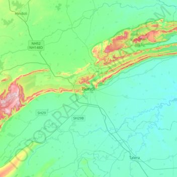
Nom : Carte topographique Bundi, altitude, relief.
Lieu : Bundi, Bundi Tehsil, Bundi District, Rajasthan, 323001, India (25.28161 75.47758 25.60161 75.79758)
Altitude moyenne : 284 m
Altitude minimum : 224 m
Altitude maximum : 542 m
Faire un don
Équipez-vous pour votre prochaine aventure :
En tant que Partenaire Amazon, ce site perçoit une commission sur les achats éligibles sans surcoût pour vous.