
Faire un don
Équipez-vous pour votre prochaine aventure :
En tant que Partenaire Amazon, ce site perçoit une commission sur les achats éligibles sans surcoût pour vous.
Carte topographique Roxbury
Cliquez sur la carte pour afficher l’altitude.
Faire un don
Équipez-vous pour votre prochaine aventure :
En tant que Partenaire Amazon, ce site perçoit une commission sur les achats éligibles sans surcoût pour vous.
Roxbury
More than twenty points within the town have an elevation of more than 2,000 feet (610 m); elevations in the town range from a low of 880 feet (270 m) (along the Third Branch of the White River) to a high of 3,086 feet (941 m) (at the peak of Rice Mountain). Rice Mountain lies in the Northfield range of the Green Mountains along the western boundary of the town.
Faire un don
Équipez-vous pour votre prochaine aventure :
En tant que Partenaire Amazon, ce site perçoit une commission sur les achats éligibles sans surcoût pour vous.
À propos de cette carte
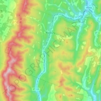
Nom : Carte topographique Roxbury, altitude, relief.
Lieu : Roxbury, Washington County, Vermont, 05669, United States (44.01281 -72.81894 44.12670 -72.63448)
Altitude moyenne : 494 m
Altitude minimum : 226 m
Altitude maximum : 969 m
Faire un don
Équipez-vous pour votre prochaine aventure :
En tant que Partenaire Amazon, ce site perçoit une commission sur les achats éligibles sans surcoût pour vous.
Autres cartes topographiques
Cliquez sur une carte pour visualiser sa topographie, son altitude et son relief.
Faire un don
Équipez-vous pour votre prochaine aventure :
En tant que Partenaire Amazon, ce site perçoit une commission sur les achats éligibles sans surcoût pour vous.
South Cabot
United States > Vermont > Washington County > Cabot > South Cabot
Altitude moyenne : 480 m
Faire un don
Équipez-vous pour votre prochaine aventure :
En tant que Partenaire Amazon, ce site perçoit une commission sur les achats éligibles sans surcoût pour vous.