
Faire un don
Équipez-vous pour votre prochaine aventure :
En tant que Partenaire Amazon, ce site perçoit une commission sur les achats éligibles sans surcoût pour vous.
Carte topographique Ramhurst
Cliquez sur la carte pour afficher l’altitude.
Faire un don
Équipez-vous pour votre prochaine aventure :
En tant que Partenaire Amazon, ce site perçoit une commission sur les achats éligibles sans surcoût pour vous.
À propos de cette carte
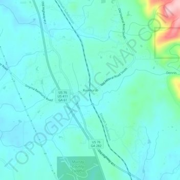
Nom : Carte topographique Ramhurst, altitude, relief.
Lieu : Ramhurst, Murray County, Georgia, United States (34.67814 -84.75077 34.71814 -84.71077)
Altitude moyenne : 245 m
Altitude minimum : 212 m
Altitude maximum : 423 m
Faire un don
Équipez-vous pour votre prochaine aventure :
En tant que Partenaire Amazon, ce site perçoit une commission sur les achats éligibles sans surcoût pour vous.
Autres cartes topographiques
Cliquez sur une carte pour visualiser sa topographie, son altitude et son relief.
Chatsworth
United States > Georgia > Murray County
Chatsworth is located in central Murray County at 34°46′20″N 84°46′44″W / 34.77222°N 84.77889°W / 34.77222; -84.77889 (34.772336, -84.778977), in northwestern Georgia. It sits at an elevation of 750 feet (230 m) on the west side of the valley of Holly Creek, with 2,840-foot (870 m) Fort…
Altitude moyenne : 241 m