
Carte topographique Oberschöllenbach
Carte interactive
Cliquez sur la carte pour afficher l’altitude.
À propos de cette carte
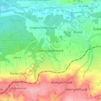
Nom : Carte topographique Oberschöllenbach, altitude, relief.
Altitude moyenne : 349 m
Altitude minimum : 299 m
Altitude maximum : 428 m
Autres cartes topographiques
Cliquez sur une carte pour visualiser sa topographie, son altitude et son relief.
Eckenhaid
Deutschland > Bayern > Landkreis Erlangen-Höchstadt > Eckental
Eckenhaid, Eckental, Landkreis Erlangen-Höchstadt, Bayern, 90542, Deutschland
Altitude moyenne : 355 m
Forth
Deutschland > Bayern > Landkreis Erlangen-Höchstadt > Eckental
Forth, Eckental, Landkreis Erlangen-Höchstadt, Bayern, 90542, Deutschland
Altitude moyenne : 341 m