
Carte topographique Vinhais
Carte interactive
Cliquez sur la carte pour afficher l’altitude.
À propos de cette carte
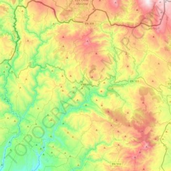
Nom : Carte topographique Vinhais, altitude, relief.
Lieu : Vinhais, Bragança, Portugal (41.67113 -7.21360 41.99076 -6.86096)
Altitude moyenne : 779 m
Altitude minimum : 258 m
Altitude maximum : 1 527 m
It is perched on the slopes of the Coroa mountains at an altitude of approximately 600 meters, protected from the cold winds of the north by the Ciradelha mountain, where in remote times there was a Luso-Roman castro. On the south side is the Tuela River valley. There are three other rivers in the concelho: the Rabaçal, the Mente, and the Baceiro. They are relatively unpolluted and provide fish for locals and tourists. The Baceiro has a trout hatchery which is deactivated but will be reopened soon.
Autres cartes topographiques
Cliquez sur une carte pour visualiser sa topographie, son altitude et son relief.
Penhas Juntas
Penhas Juntas, Vinhais, Bragança, Portugal
Altitude moyenne : 715 m
Montesinho Nature Park
Portugal > Bragança > Bragança > Espinhosela
Montesinho Nature Park, Espinhosela, Bragança, 5300-245, Portugal
Altitude moyenne : 881 m
Carrazeda de Ansiães
Carrazeda de Ansiães, Bragança, Portugal
Altitude moyenne : 538 m
Macedo de Cavaleiros
Portugal > Bragança > Macedo de Cavaleiros
Macedo de Cavaleiros, Bragança, Portugal
Altitude moyenne : 594 m
Mua
Portugal > Bragança > Torre de Moncorvo
Mua, Torre de Moncorvo, Bragança, Portugal
Altitude moyenne : 695 m