
Carte topographique Papandayan
Carte interactive
Cliquez sur la carte pour afficher l’altitude.
À propos de cette carte
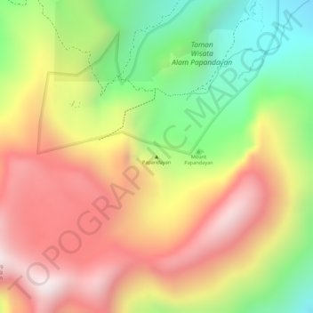
Nom : Carte topographique Papandayan, altitude, relief.
Lieu : Papandayan, Bandung, Java occidental, Indonésie (-7.32005 107.72995 -7.31995 107.73005)
Altitude moyenne : 2 319 m
Altitude minimum : 1 938 m
Altitude maximum : 2 638 m
Autres cartes topographiques
Cliquez sur une carte pour visualiser sa topographie, son altitude et son relief.
Gunung Patuha
Indonésie > Java occidental > Bandung
Gunung Patuha, Bandung, Java occidental, 40973, Indonésie
Altitude moyenne : 2 103 m
Gunung Kendang
Indonésie > Java occidental > Bandung
Gunung Kendang, Bandung, Java occidental, Indonésie
Altitude moyenne : 2 284 m