
Carte topographique Amherst
Carte interactive
Cliquez sur la carte pour afficher l’altitude.
À propos de cette carte
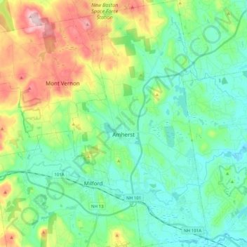
Nom : Carte topographique Amherst, altitude, relief.
Altitude moyenne : 127 m
Altitude minimum : 50 m
Altitude maximum : 320 m
According to the United States Census Bureau, the town has a total area of 34.7 square miles (89.9 km2), of which 34.2 square miles (88.5 km2) is land and 0.54 square miles (1.4 km2), or 1.51% of the total area, is water. Located on the Souhegan River, Amherst is drained by Beaver, Bloody, and Joe English brooks. Amherst's highest point is on Chestnut Hill at the town's northern border, where the elevation reaches 865 feet (264 m) above sea level. Amherst lies fully within the Merrimack River watershed.