
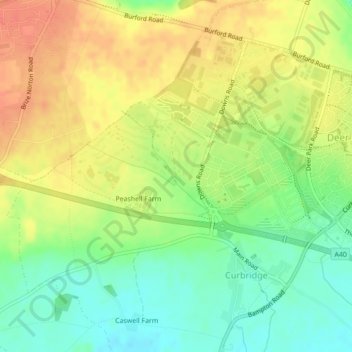
Carte topographique Elm Bank
Carte interactive
Cliquez sur la carte pour afficher l’altitude.
À propos de cette carte
Nom : Carte topographique Elm Bank, altitude, relief.
Altitude moyenne : 101 m
Altitude minimum : 77 m
Altitude maximum : 122 m
Autres cartes topographiques
Cliquez sur une carte pour visualiser sa topographie, son altitude et son relief.
West Oxfordshire
United Kingdom > England > West Oxfordshire
West Oxfordshire, Oxfordshire, South East, England, United Kingdom
Altitude moyenne : 119 m
Combe
United Kingdom > England > West Oxfordshire
Combe, West Oxfordshire, Oxfordshire, South East, England, United Kingdom
Altitude moyenne : 106 m
Cornbury and Wychwood
United Kingdom > England > West Oxfordshire
Cornbury and Wychwood, West Oxfordshire, Oxfordshire, South East, England, United Kingdom
Altitude moyenne : 146 m
Neat Enstone
United Kingdom > England > West Oxfordshire > Neat Enstone
Neat Enstone, West Oxfordshire, Oxfordshire, South East England, England, OX7 4NX, United Kingdom
Altitude moyenne : 159 m