
Carte topographique Town of Guilderland
Carte interactive
Cliquez sur la carte pour afficher l’altitude.
À propos de cette carte
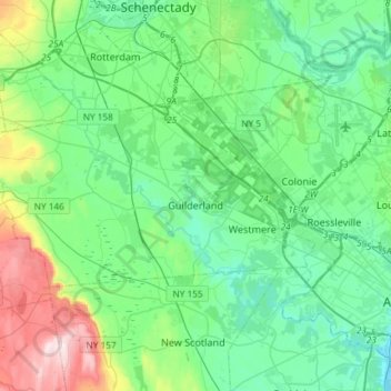
Nom : Carte topographique Town of Guilderland, altitude, relief.
Lieu : Town of Guilderland, Albany County, New York, United States (42.65915 -74.10672 42.76064 -73.81251)
Altitude moyenne : 126 m
Altitude minimum : 2 m
Altitude maximum : 551 m
Autres cartes topographiques
Cliquez sur une carte pour visualiser sa topographie, son altitude et son relief.
Albany
United States > New York > Albany County > Albany
The highest natural point in Albany is a USGS benchmark near the Loudonville Reservoir off Birch Hill Road, at 378 feet (115 m) above sea level. The lowest point is sea level at the Hudson River (the average water elevation is 2 feet (0.61 m)), which is still technically an estuary at Albany and is affected by…
Altitude moyenne : 114 m