
Carte topographique Cabbage Island
Carte interactive
Cliquez sur la carte pour afficher l’altitude.
À propos de cette carte
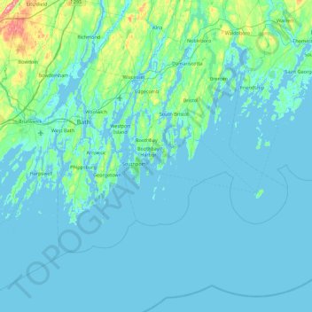
Nom : Carte topographique Cabbage Island, altitude, relief.
Altitude moyenne : 17 m
Altitude minimum : -6 m
Altitude maximum : 213 m
Autres cartes topographiques
Cliquez sur une carte pour visualiser sa topographie, son altitude et son relief.
East Boothbay
United States > Maine > Lincoln County > Boothbay
East Boothbay, Boothbay, Lincoln County, Maine, 04568, United States
Altitude moyenne : 16 m
Barters Island
United States > Maine > Lincoln County > Boothbay
Barters Island, Boothbay, Lincoln County, Maine, 04571, United States
Altitude moyenne : 18 m