
Faire un don
Équipez-vous pour votre prochaine aventure :
En tant que Partenaire Amazon, ce site perçoit une commission sur les achats éligibles sans surcoût pour vous.
Carte topographique Akutan Island
Cliquez sur la carte pour afficher l’altitude.
Faire un don
Équipez-vous pour votre prochaine aventure :
En tant que Partenaire Amazon, ce site perçoit une commission sur les achats éligibles sans surcoût pour vous.
À propos de cette carte
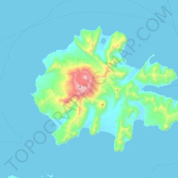
Nom : Carte topographique Akutan Island, altitude, relief.
Altitude moyenne : 102 m
Altitude minimum : -4 m
Altitude maximum : 1 278 m
Faire un don
Équipez-vous pour votre prochaine aventure :
En tant que Partenaire Amazon, ce site perçoit une commission sur les achats éligibles sans surcoût pour vous.
Autres cartes topographiques
Cliquez sur une carte pour visualiser sa topographie, son altitude et son relief.
Shishaldin Volcano
United States > Alaska > Aleutians East Borough
Shishaldin is located on Unimak Island, the easternmost of the Aleutian Islands. The nearest settlement to the volcano is False Pass (population ~100) at 45 km away. The view of Shishaldin from False Pass is obscured by the Round Top and Isanotski volcanoes, preventing direct observations of eruptions in many…
Altitude moyenne : 2 134 m
Faire un don
Équipez-vous pour votre prochaine aventure :
En tant que Partenaire Amazon, ce site perçoit une commission sur les achats éligibles sans surcoût pour vous.